

USA Toroweap Overlook
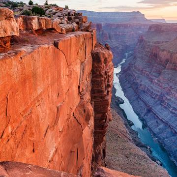
Toroweap Overlook is located in a remote section of the Grand Canyon on the North Rim. The canyon rim overlooks a 3000 foot sheer vertical drop to the Colorado River far below. In this photo, the three white dots in the river are rafts approaching one of the river’s most notorious rapids, Lava Falls. There are nine camping spots nearby at the Tuweep Campground. Back country permits and camping fees are required for Tuweep and sometimes must be acquired (online) up to 4 months in advance. However there are numerous free camping spots along the various routes to Toroweap.
Photography Tips
As usual, sunrise and sunset is best and even better if you can manage to be there when there are clouds. I’ve seen some great Milky Way photos but you almost have to camp nearby for that. During the optimum summer months for Milky Way photography, I wouldn’t want to hike the extremely rugged road at night. I’m not personally aware of any incidents, but this is rattlesnake country which is something to be aware of day or night but they’re more active at night. Also, there are no barriers of any kind along the canyon rim, so be very careful when hiking and/or photographing there.
Travel Information
There are three options to drive to Toroweap. The “Sunshine Route” (County road #109), is the primary and more reliable access route. It leaves Highway 389 8mi / 13km west of Fredonia (6mi / 10km east of Pipe Spring National Monument). The road is 61 miles (98km) long but is subject to sharp rocks (flat tires), wash-boarding, and dust. The U.S.National Park Service states that 25% of visitors get one or more flat tires on the road to or from Toroweap, so good tires and at least one good spare tire is essential. The key is to take your time and don’t speed over the rocks. Aside from some periodic wash boarding, the first 58 miles of the road is OK for 2WD vehicles if the road is dry. However, a high clearance vehicle with 4WD is mandatory for the last few miles. There’s a parking area for travelers with 2WD only can park and hike the last few miles. I would avoid that hike in the summer (June/July/August), when temperatures can easily exceed 110° F (43.33 C). We drove a high clearance 4WD truck at a pretty good speed almost to the canyon rim and it still took us a little over three hours to drive the 61 miles.
Spot Type
Outdoor
Crowd Factor
Nearly no other people
Best Timing
Sunset during fall
Sunrise & Sunset
05:51 - 19:11
| current local time: 14:17
Photo Themes
Canyon Landscape
Locations
grand canyon national park
Spot Comments (0)