Meenuliyan Para, India
Lipinkumar (Lk)
Lipinkumar (Lk) www.lipinkumar.com
This photo is copyrighted by the author.
Thank you for respecting the rights and efforts of our photographers. Please contact the author for further information.

India Meenuliyan Para

  • Please log in or sign up for free to see the GPS coordinates & weather for this photo spot
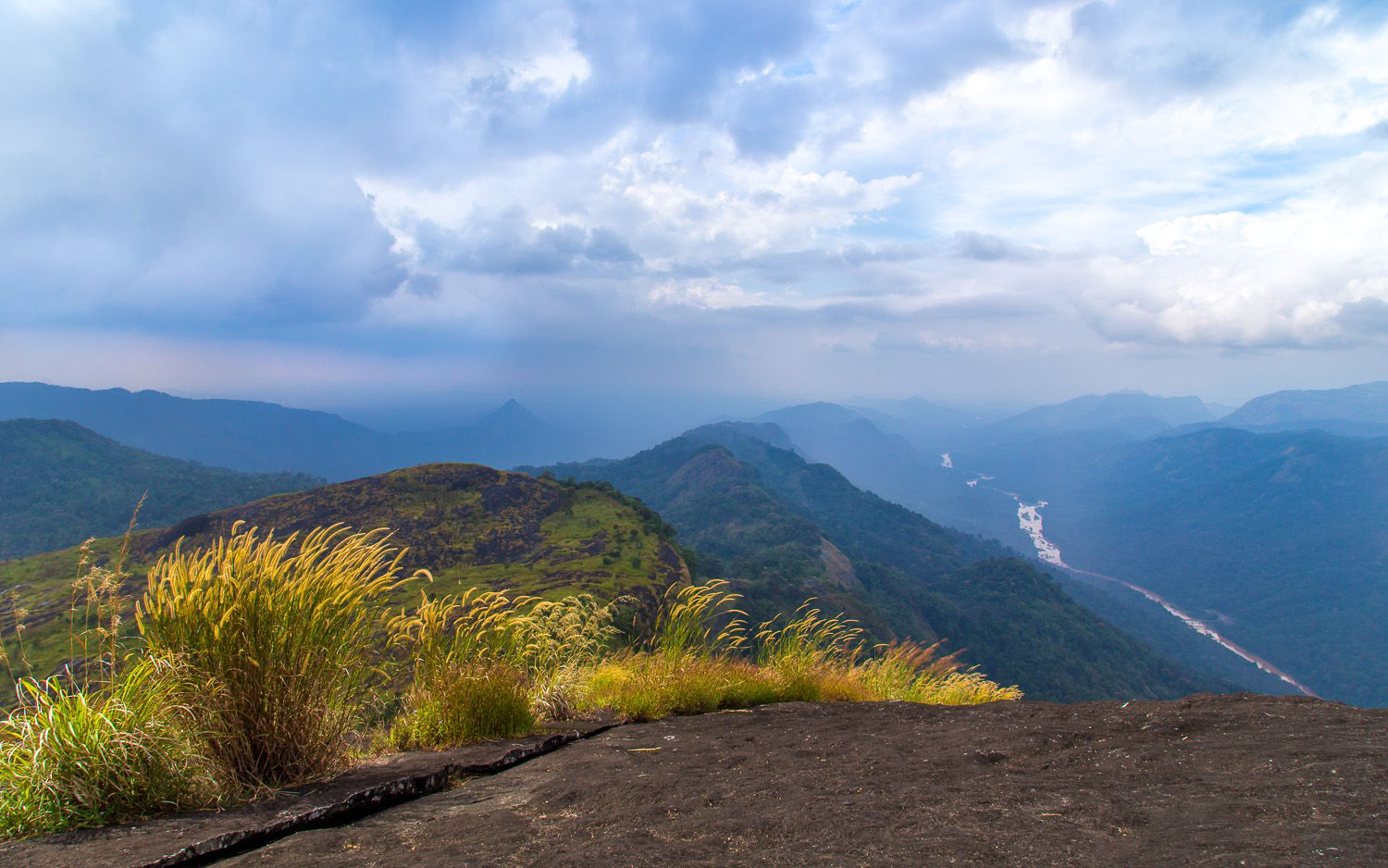
Though you'll have to climb all the way to the top of the hill, the view is spectacular and there's cool wind to give you the most relaxing time. The place doesn't attract much tourists, so you'd have the hill top to your's all day long.

Photography Tips

Pack light and carry some water for you'll be tired once you reach the top. There are always chances of a drizzle so take care of your gear from rain and moisture. And be cautious, the wind can get a bit strong sometimes, so mind the tripod, it shouldn't fall down or get shakes due to the wind.

Travel Information

Though public transport (buses) is available, the timing might not suit and the frequency is less. So, you'll have to drive to this place, and it's a good experience too.
Spot Type Outdoor
Crowd Factor Nearly no other people
Best Timing Spring
Sunrise & Sunset 06:20 - 18:34 | current local time: 10:59
Photo Themes Mountain River viewpoint
Locations Meenuliyan Para

Get the exact geo-position for this spot

Log in to see the GPS coordinates, sun directions, and the map for this photo spot. Or simply bookmark it along with other spots to plan your next trip.

Spot Comments (3)

Please log in or sign up for free to leave a comment or ask a question.
Yoosaf Abdulla
Yoosaf Abdulla 25.11.2015
Hi Lipin, is the trek a guided one or you can go by yourself. and how long does it take. Which is the nearest railway station?
Lipinkumar (Lk)
Lipinkumar (Lk) 17.06.2018
this is a trek that you can go by yourself. there aren't any authorized guides at this spot, since this isn't a much explored area. It s basically known to the locals. You can get advise from the local personnel (shopkeepers, drivers etc.) who can give a brief of how to go by the trek. It took us almost 2 hrs to reach the top with ample rest. The nearest railway station would be Alwaye, which itself is approx. 70 km. The nearby towns are Kothamangalam and Muvattupuzha.
Manuel Becker Team
Manuel Becker 24.03.2015
Looks like an amazing viewpoint Lipinkumar, thanks for sharing it! I changed the tags, so that others can find this place by searching for mountain or river (because you have a great view down to this river), but everything else is perfect, thanks for your tips! :)

Ratings (1) starstarstarstarstar

starstarstarstarstar
1
starstarstarstarstar
0
starstarstarstarstar
0
starstarstarstarstar
0
starstarstarstarstar
0

Popular photo spots in this region

Thank you Lipinkumar (Lk) for creating this photo spot in India.
Imprint & Contact © Locationscout 2024 Privacy / Terms