
USA House on Fire Ruins
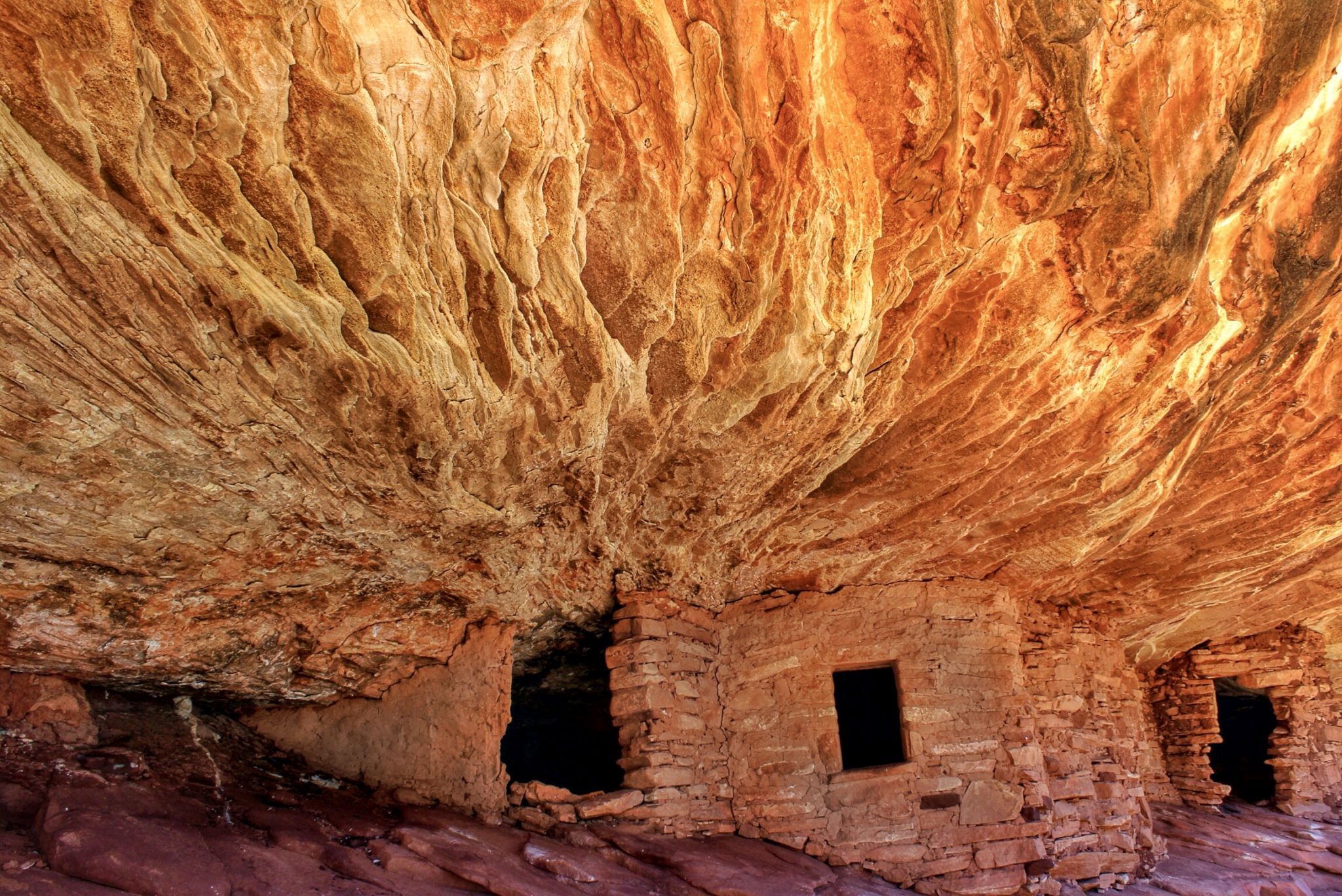
The name of this Anasazi Indian ruin comes from the swirly, striated patterns on the rock roof above the structures that turns a brilliant red in certain lights - making it look like an inferno is engulfing the roof of the rooms. It is also called the Flaming House Ruin or the Flaming Ceiling Ruin. Mule Canyon is the site of several other ruins and are from 700 to 2500 years old. The nearby Natural Bridges National Monument has several huge natural bridges (similar to an arch). Also, the drive between Mule Canyon and Hanksville, Utah via Hwy. 95 is in my opinion the most dramatic drive in Utah and should not be missed.
Photography Tips
To get the iconic photograph of the “flames,” visit early to mid-morning (depending on the time of the year). The idea is to get there early enough to get the reflected light bouncing off the canyon walls but before the light hits the wall directly and washes it out. It’s better to be early than late. The “flame” effect can disappear in just a few minutes.
Travel Information
Take Utah state Route 95 to the junction with County Road 263/Texas Flat Road. This junction lies halfway between Blanding, Utah and Natural Bridges National Monument near Highway 95 mile marker 102. Travel north on 263, and you'll immediately see the kiosk to pay for your permit to hike to House on Fire. The permit costs $2 per person for the day. There is a sign for Mule Canyon, but this is not the trailhead. Rather, it’s a BLM exhibit with a kiva, interpretive signing, and a pit toilet. From the kiosk, continue traveling approximately 0.3 miles to the parking area on the right. The trailhead is on the left. Starting from the pull off, scramble down into the wash where you'll find a trailhead sign and sign-in station. The narrow trail initially heads north and follows the contours of the stream, crossing it several times. Low scrubby vegetation and cottonwoods predominate. Bend to the northwest and continue hiking gently uphill for about 1 mile. The ruins are not directly on the trail, so look to your right (north) for rock structures along a cliff alcove about 50 feet above. A side-trail threads through some bushes to the base of some low-angle slickrock. Follow this and rock pile cairns to the base of the ruins.
Spot Type
Outdoor
Crowd Factor
Nearly no other people
Best Timing
Sunrise in fall
Sunrise & Sunset
06:13 - 20:37
| current local time: 23:54
Photo Themes
Ancient Anasazi Ruins
Rock
Locations
Utah
Mule Canyon in Cedar Meas


Spot comments (0)