
USA Buckskin Gulch
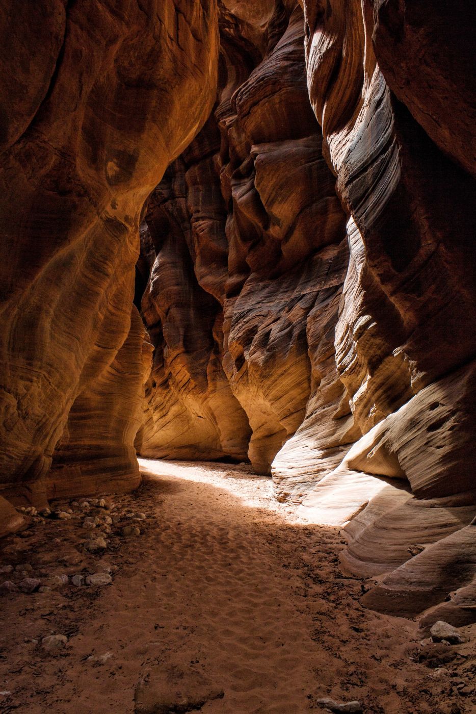
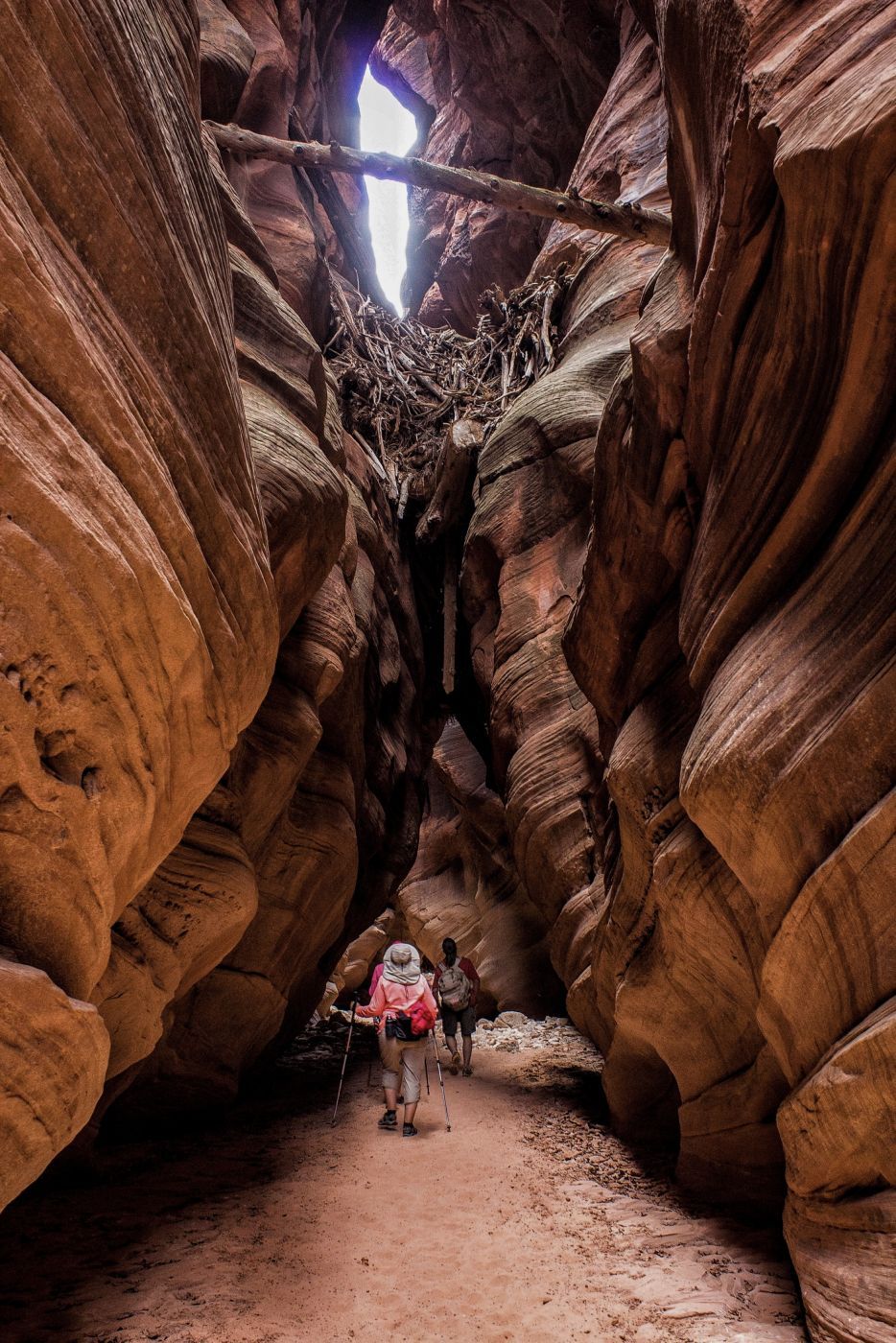
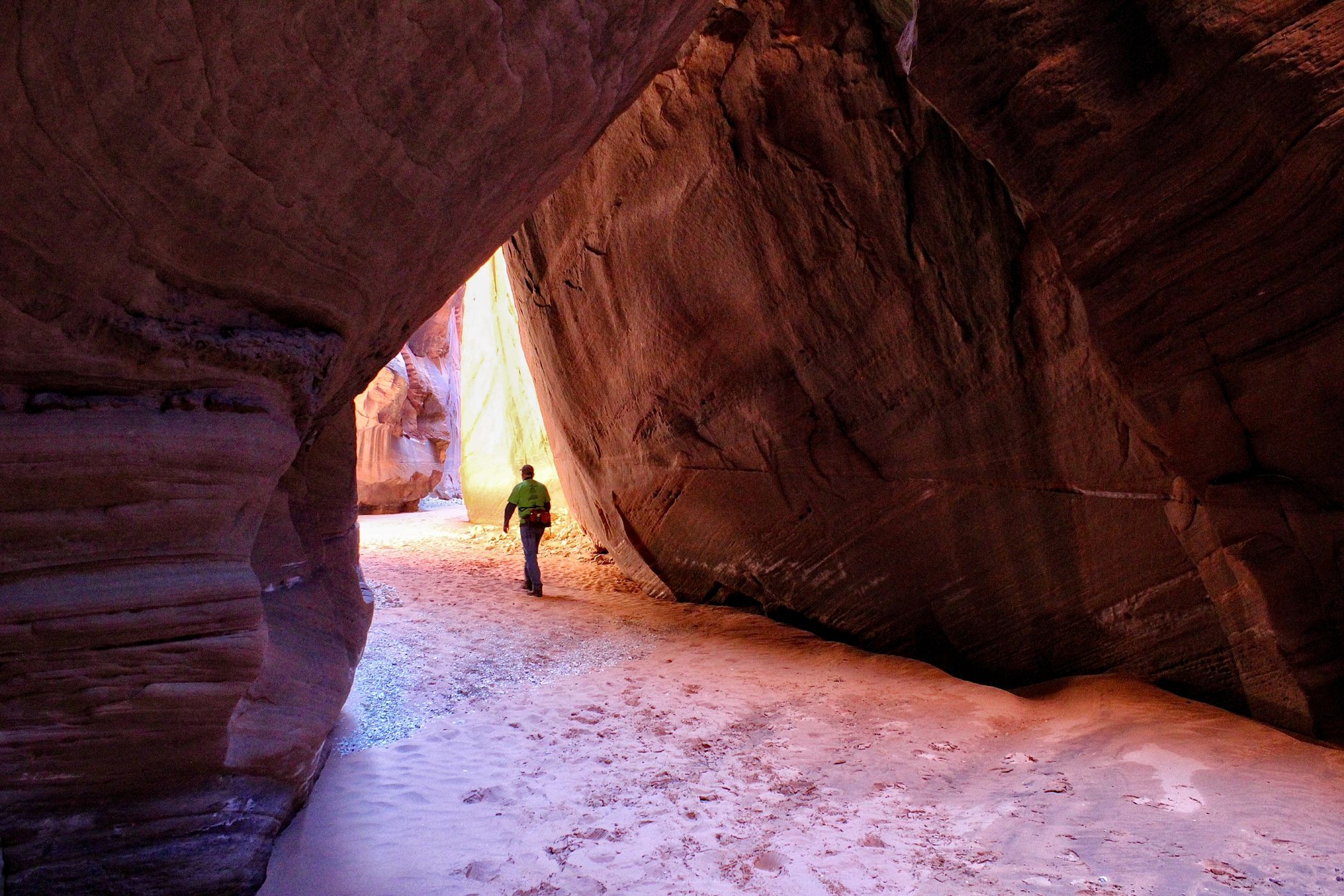
Buckskin Gulch is purportedly the longest slot canyon on earth and certainly is the longest in the U.S. at approximately 15 miles. I’ve explored many slot canyons across Utah and this one ranks among the best. Many hikers choose to explore the entire canyon as a multi-day backpack. I’ve only gone about 3 miles down Buckskin and turned around due to time constraints (once) and water pools several times. There are almost always pools of water at different sections throughout the canyon. Some are short and shallow. Others are longer and may require swimming. A lot of the canyon floor never sees the rays of the sun so if water is there, it will probably be ice cold. The view at every turn is extraordinary.
Photography Tips
For the beginner photographer, I would suggest shooting in aperture priority and auto ISO if you have the capability.
Travel Information
From Kanab, Utah drive east on Highway 89 for 38 miles (61 km) and turn right on House Rock Valley Road, just before the highway turns sharply left at the beginning of the guardrail and goes through a deep road cut. This is a very abrupt turn and is easy to miss if you’re not looking for it. There is a sign for Buckskin Gulch trailhead 4.4 miles (7.08 km) down House Rock Valley Road. My advice is DON’T TURN THERE! It would add at least four miles to your hike and those 4 miles are rather dull and unexciting. Instead, continue to the Wire Pass trailhead which is 8.3 miles (13.4 km) from the highway junction. The road is dirt and gravel, and in wet weather, it can become impassable. In the winter, the frequently frozen (and passable) road in the morning can become a slushy (and impassable) road in the afternoon (been there, done that). The Wire Pass trailhead can also be reached from the south via Highway 89A, about 18 miles (29 km) west of Cliff Dweller’s Lodge. Turn north on House Rock Valley Road just before 89A starts to climb the Kaibab Plateau. The trailhead is about 22 miles (35.4 km) from the highway junction. Pit toilets are in place at the Wire Pass Trailhead parking area. The fee for day hikes is $6 (US). Overnight/multi-day hikes require a permit. Check the BLM website or Recreation.gov for North Coyote Buttes permit and payment instructions. After parking and signing in at the trail register, cross the road and drop into a sandy/gravel wash and turn left. After about a half mile (.8 km), you’ll see a sign on a narrow path on the right side of the wash that leads to Coyote Buttes North (The Wave). DO NOT TURN THERE! BLM (Bureau of Land Management) rangers monitor that route via cameras, BLM rangers, and volunteers to ensure hikers have the required permit for The Wave. Instead, continue down the wash for about 1 mile (1.6 Km). After a short and shallow section, you’ll come to a climb-down obstacle that varies in difficulty depending on the last flash flood. There’s a large chockstone at the top of the obstacle. The last time I was there, the drop was about eight feet. The Bureau of Land Management placed a heavy wooden ladder at that spot. A second ladder placed there was washed away by a flash flood. Check with the BLM for current conditions before you go. In any case, there is a bypass route about 20 yards before the obstacle. There’s a narrow path on the right side of the wash leading up and over a hill, then winds back down to the canyon floor about 20 yards downstream of the obstacle. Beyond this obstacle is where the trek gets interesting. Wire Pass narrows to just a few feet wide in places and twists and turns for about a half mile before reaching the confluence with Buckskin Gulch. The hike to the confluence is the destination for many hikers as it includes stretches of beautiful, brilliantly coloured walls. As you exit Wire Pass, you’ll see a large alcove on your right. Beyond the alcove, there are a few small but interesting petroglyphs and pictographs located near the bottom of the wall just before Buckskin Gulch. Turn right at Buckskin and be prepared to be awestruck.
DO NOT enter Wire Pass or Buckskin Gulch if rain is in the forecast. Many people have met a tragic end after being swept away by flash floods in slot canyons.
DO NOT enter Wire Pass or Buckskin Gulch if rain is in the forecast. Many people have met a tragic end after being swept away by flash floods in slot canyons.
Spot Type
Outdoor
Crowd Factor
Just a few people
Best Timing
Sunrise in fall
Sunrise & Sunset
06:23 - 20:45
| current local time: 19:46
Photo Themes
Rock Formation
Slot Canyon
Locations
Utah
Coyote Buttes North


Spot comments (2)