
USA Buckskin Gulch
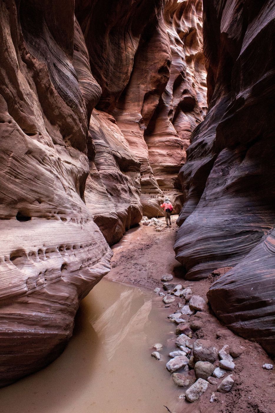
Buckskin Gulch is purportedly the longest slot canyon on earth and certainly is the longest in the U.S. at approximately 15 miles. I’ve explored many slot canyons across Utah and this one ranks among the best. Many hikers choose to explore the entire canyon as a multi-day backpack. I’ve only gone about 3 miles down Buckskin and turned around due to time constraints (once) and water pools several times. There are almost always pools of water at different sections throughout the canyon. Some are short and shallow. Others are longer and may require swimming. A lot of the canyon floor never sees the rays of the sun so if water is there, it will probably be ice cold. After a couple of miles, Buckskin alternatively widens to 20-30 yards with huge alcoves and then narrows again to just a few feet. The view at every turn is extraordinary.
Photography Tips
For the beginner photographer, I would suggest shooting in aperture priority and auto ISO if you have the capability.
Travel Information
From Kanab, Utah, drive east on Highway 89 for 38 miles and turn right on House Rock Valley Road, just before the highway turns sharply left at the beginning of the guardrail and goes through a deep road cut. This is a very abrupt turn and is easy to miss if you’re not looking for it. The Buckskin Gulch trailhead is 4.4 miles down House Rock Valley Road. DON’T TURN THERE! It would add at least for miles to your hike. Instead, continue to the Wire Pass trailhead, which is 8.3 miles from the highway junction. The road is dirt and gravel, and in wet weather, it can become impassable. In the winter, the frequently frozen (and passable) road in the morning becomes a slushy (and impassable) road in the afternoon (been there, done that).
The trailhead can also be reached from the south via Highway 89A, about 18 miles west of Cliff Dweller’s Lodge. Turn north on House Rock Valley Road just before 89A starts to climb the Kaibab Plateau. The trailhead is about 22 miles from the highway junction.
Pit toilets are in place at the large Wire Pass Trailhead parking area. A day-use permit is $6 (US), payable at the trailhead (see Recreation.gov website for detailed instructions. There is no one at the trailhead to collect fees.). Overnight/backpacking permits must be acquired in advance (see Recreation.gov).
After parking and signing in at the trail register, cross the road, drop into a sandy/gravel wash, and turn left. After about a half mile, you’ll see a sign and a narrow path on the right side of the wash leading you to Coyote Buttes North (The Wave). DO NOT TURN THERE! BLM rangers monitor that route to ensure hikers have the required permit for The Wave. Continue down the wash for about 1 mile. After a short and shallow section, you’ll come to a climb-down obstacle that varies in difficulty depending on the last flash flood. There’s a large chockstone at the top of the obstacle. The last time I was there, the drop was about eight feet. There is usually a log and/or rocks piled below the chockstone that is used to assist the climb down/up. Unfortunately, the obstacle is enough to dissuade some hikers. However, there is a relatively easy bypass to this obstacle. About 20 yards before the obstacle, there’s a narrow path on the right side of the wash leading up and over the hill, then winds back down to the canyon floor about 20 yards downstream of the obstacle. This is where the trek gets interesting. Wire Pass narrows to just a few feet in places and twists and turns for about a half mile before reaching the confluence with Buckskin Gulch. The hike through Wire Pass to the confluence with Buckskin is the destination for many as it includes stretches of beautiful, brilliantly colored walls. As you exit Wire Pass, you’ll see a large alcove on your right. Beyond the alcove, there are a few small but interesting petroglyphs and pictographs located near the bottom of the wall just before Buckskin Gulch. Turn right at Buckskin and be prepared to be awestruck.
Update: Sometime during the past year (2023-2024), the BLM placed a large cedar ladder at the drop-down obstacle, making the hike much easier. I believe this is the third ladder they’ve placed after the previous ladders were washed away by flash floods. Check with the Bureau of Land Management before your visit to see if the ladder is still there.
Spot Type
Outdoor
Crowd Factor
No info yet
Best Timing
All timings are equally good
Sunrise & Sunset
06:23 - 20:45
| current local time: 19:46
Photo Themes
Rock Formation
Slot Canyon
Locations
Utah
Coyote Buttes North


Spot comments (0)