

USA Zion Subway
If I’m to call attention to this spot I feel obligated to provide as much detail as possible so you’ll know well in advance the effort required to get there. Especially if you’re traveling from out of this country. I apologize in advance for being long winded. Along with the Angels Landing and Zion Narrows hikes, the Zion Subway hike is on many “top hikes” lists in the U.S. One must have a sense of adventure and be in reasonably good physical condition to complete the hike to the Subway but it is truly spectacular. You constantly cross from one side of the cold waterway to the other and much of the route is in the creek itself. The route frequently requires climbing directly up the cascades and waterfalls, none of which is difficult at all and adds to the experience. The “Top Down” hike is a one way “thru” hike that requires a shuttle and requires numerous rappels to get to the “Subway” section of the hike. The “Bottom Up” hike starts and ends at the same trailhead and requires no ropes or rappels. Both routes are about 9 miles (14.5 km) total. Both routes DO require a permit that can be acquired online or at the Back Country desk at the Zion N.P. Visitor Center. I believe only 40 permits are allotted for each day. Take plenty of water (or a filtration device) and snacks.
Start as early as possible (sunrise is good) especially in the summer when temperatures can easily exceed 100° F (38° C). Overestimate the time you think it will take you to complete the hike. You DON'T want to have to look for the trail leading up the steep canyon wall or attempt to climb out in the dark. Many hikers have spent the night in the canyon after missing the trail. Due to the extremely rough terrain, Search and Rescue teams will not typically initiate a rescue until the next morning.
On the bottom up hike, you'll hike about 1/2 mile (0.8 km) across brushy, well defined but rugged terrain before you get to the edge of the canyon wall. The trail then steeply switchbacks down the canyon wall to the creek for a couple of hundred yards. While there’s nothing technical here, you will have to occasionally use your hands on the way down and up. While there are few if any major drop offs along the descent, a misstep could result in a long and potentially catastrophic tumble. When you get to the canyon floor, be sure to turn around and look where you came from. It's very easy to miss the trail leading back out of the canyon. Get a good mental picture of the trail or better yet, take a picture and/or GPS waypoint and refer to it on the hike back. The last time I was there, someone had tied a length of pink tape on a bush to mark the trail which was very helpful. However, you crisscross the creek throughout the hike and could easily be on the wrong side of the creek and not notice the trail leading up the wall. I suggest that after your initial climb down, turn around and look again after you've walked a couple hundred yards up the river to see what the wall looks like that you just climbed down.
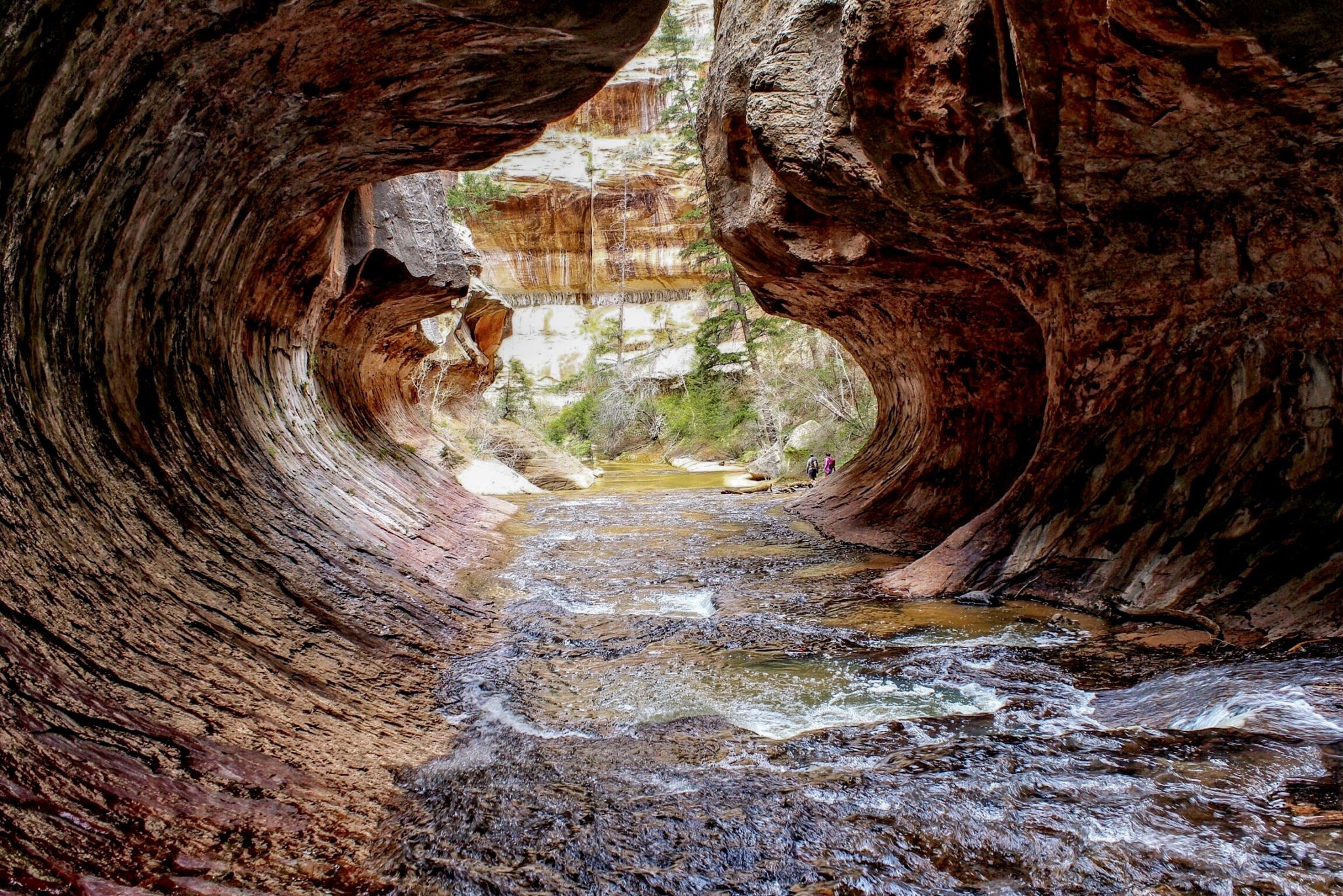
Having done this hike several times I suggest walking in the river as much as you possibly can. In my opinion, it's a lot easier than the frequent ups and downs following the foot paths on either side of the creek that sometimes require climbing up and over or around obstacles. You're gonna get your feet wet anyway and hopefully, you're wearing water shoes and neoprene socks. If you don't have them, I recommend buying or renting them. Also, I can't imagine doing the hike without a hiking pole or trekking sticks. Everything you need can be rented for about $30 U.S. from any of the numerous outfitters in Springdale, just outside the south entrance to Zion National Park.
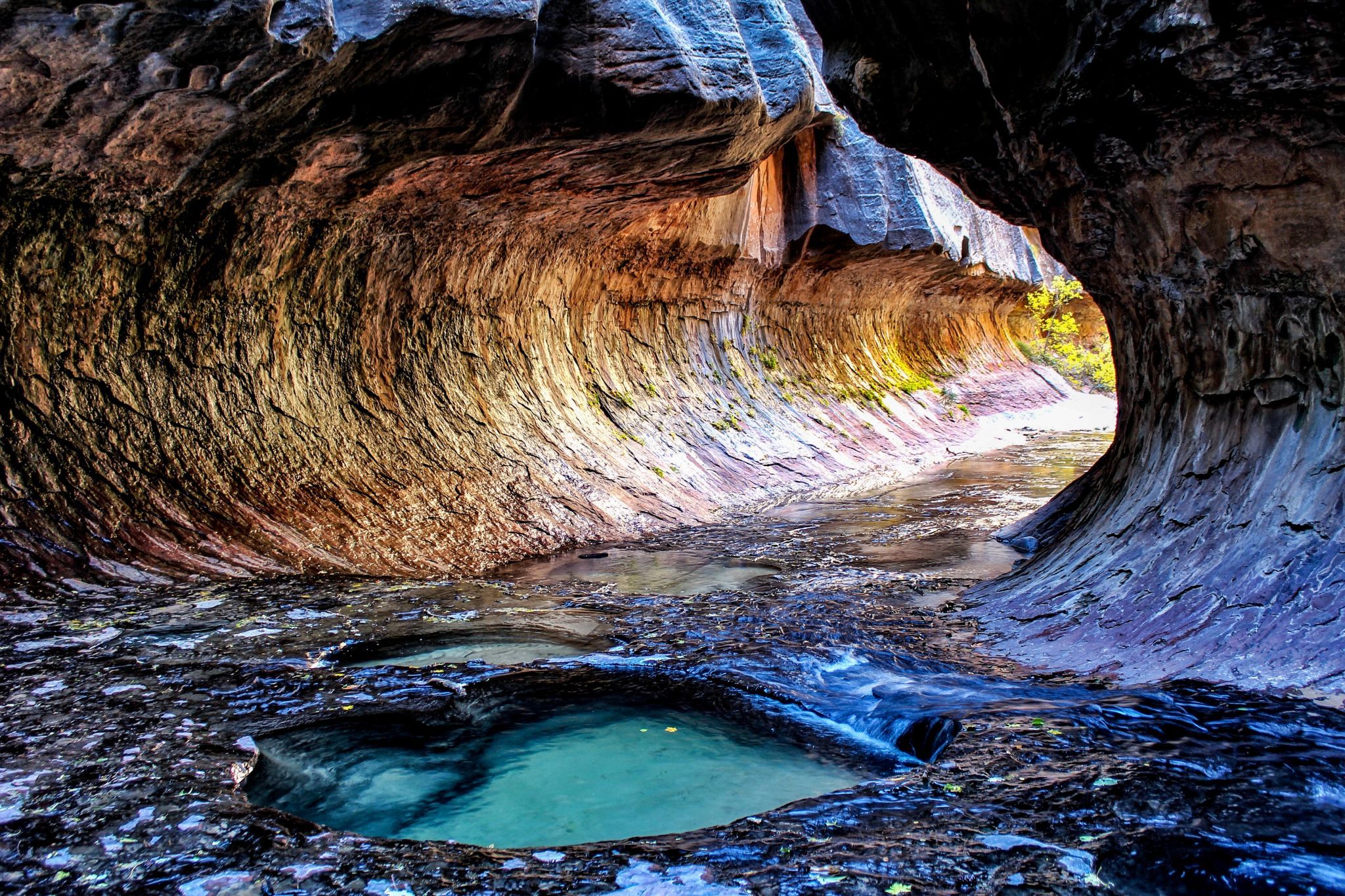
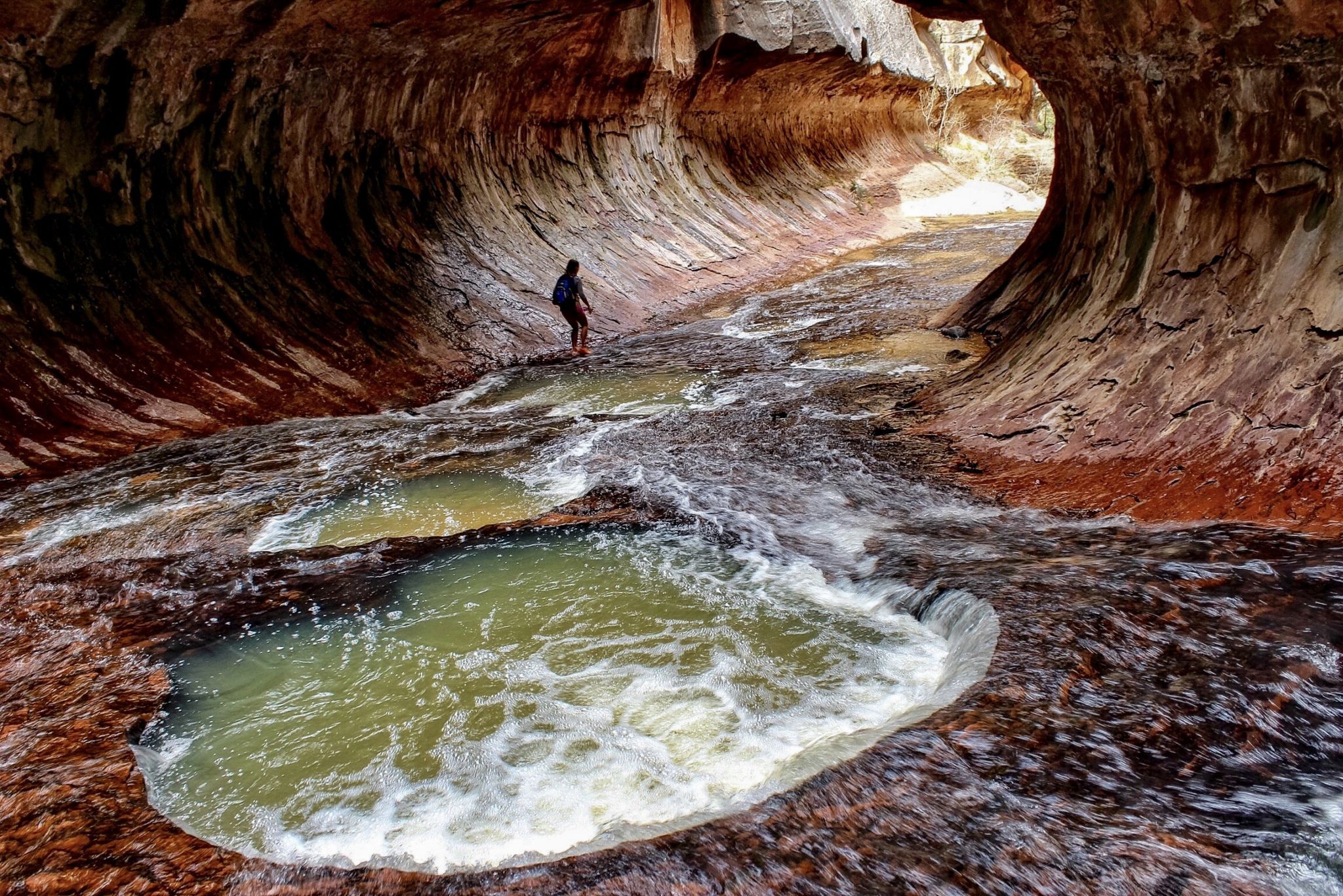
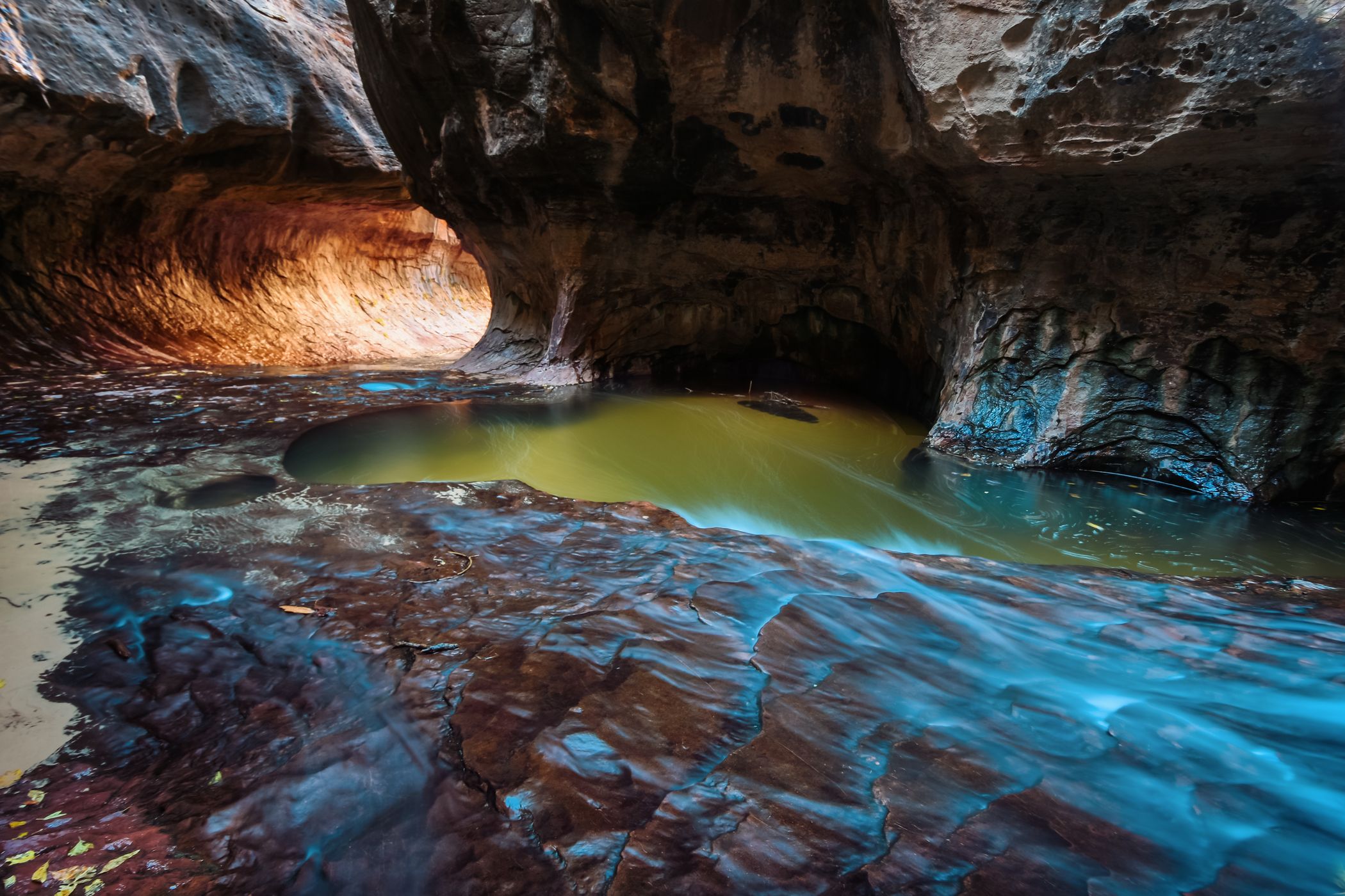
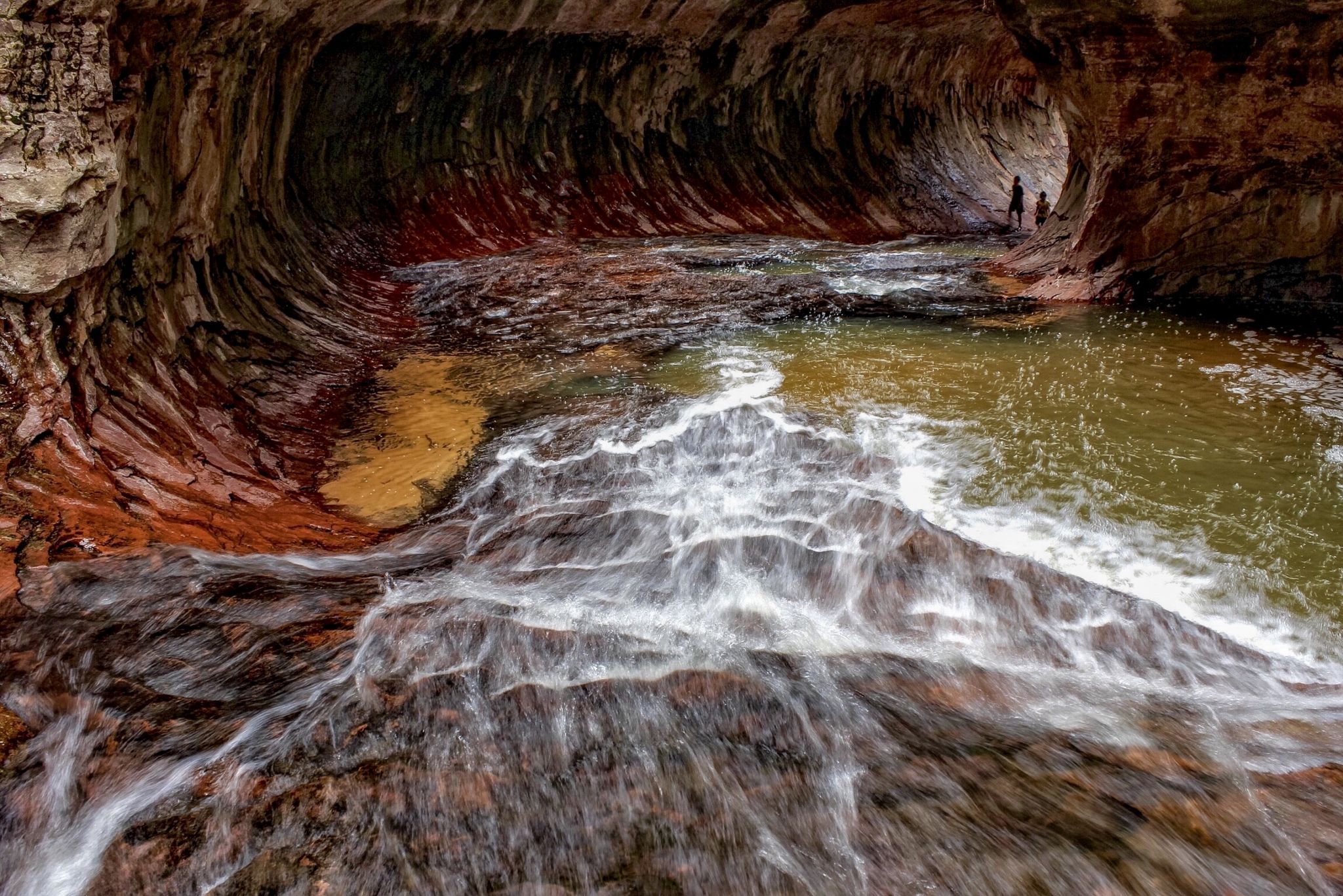
Save some energy for the hike back up the wall at the end of the day. It's only a few hundred yards up and not particularly treacherous but is very steep and by the end of the day really gets my lungs screaming. Much of the hike is in the water and on slickrock. You'll find that the red, yellow, or white rock is "tacky" and easy to walk on. The dark green or black rock (covered with algae or moss) is slippery as hell. Especially in the actual “Subway” area. I bet a LOT of people slip and fall there. I'm pretty surefooted but have come close to going down several times there. The young lady in this photo went down about one half second after I snapped this picture but fortunately got up laughing.
The last time I went to the Subway, there was a rope left hanging in the actual "Subway" by some "top down" hikers (where “bottom up” hikers eventually turn around). I climbed up the rope thinking I might be able to explore a little farther up the canyon. The problem is after you climb the rope, you walk along the somewhat slippery ledge for about 20 feet and then have to make a little jump (about 3 feet) to cross a gap to the other side which would not be difficult but the jump BACK would be a little hairy since there's a lot of slippery moss/algae you have to land on (at least there was when I was there). If you slip on the landing, the 15 foot drop could be damaging. I opted to turn around. I was able to get a few interesting pics from a slightly different perspective but in my opinion it's not worth the climb up and wouldn't recommend it. Besides, if there is a rope, you don't know how long it might have been hanging there or what condition it's in. In retrospect, I shouldn’t have risked it.
Start as early as possible (sunrise is good) especially in the summer when temperatures can easily exceed 100° F (38° C). Overestimate the time you think it will take you to complete the hike. You DON'T want to have to look for the trail leading up the steep canyon wall or attempt to climb out in the dark. Many hikers have spent the night in the canyon after missing the trail. Due to the extremely rough terrain, Search and Rescue teams will not typically initiate a rescue until the next morning.
On the bottom up hike, you'll hike about 1/2 mile (0.8 km) across brushy, well defined but rugged terrain before you get to the edge of the canyon wall. The trail then steeply switchbacks down the canyon wall to the creek for a couple of hundred yards. While there’s nothing technical here, you will have to occasionally use your hands on the way down and up. While there are few if any major drop offs along the descent, a misstep could result in a long and potentially catastrophic tumble. When you get to the canyon floor, be sure to turn around and look where you came from. It's very easy to miss the trail leading back out of the canyon. Get a good mental picture of the trail or better yet, take a picture and/or GPS waypoint and refer to it on the hike back. The last time I was there, someone had tied a length of pink tape on a bush to mark the trail which was very helpful. However, you crisscross the creek throughout the hike and could easily be on the wrong side of the creek and not notice the trail leading up the wall. I suggest that after your initial climb down, turn around and look again after you've walked a couple hundred yards up the river to see what the wall looks like that you just climbed down.
Having done this hike several times I suggest walking in the river as much as you possibly can. In my opinion, it's a lot easier than the frequent ups and downs following the foot paths on either side of the creek that sometimes require climbing up and over or around obstacles. You're gonna get your feet wet anyway and hopefully, you're wearing water shoes and neoprene socks. If you don't have them, I recommend buying or renting them. Also, I can't imagine doing the hike without a hiking pole or trekking sticks. Everything you need can be rented for about $30 U.S. from any of the numerous outfitters in Springdale, just outside the south entrance to Zion National Park.
Save some energy for the hike back up the wall at the end of the day. It's only a few hundred yards up and not particularly treacherous but is very steep and by the end of the day really gets my lungs screaming. Much of the hike is in the water and on slickrock. You'll find that the red, yellow, or white rock is "tacky" and easy to walk on. The dark green or black rock (covered with algae or moss) is slippery as hell. Especially in the actual “Subway” area. I bet a LOT of people slip and fall there. I'm pretty surefooted but have come close to going down several times there. The young lady in this photo went down about one half second after I snapped this picture but fortunately got up laughing.
The last time I went to the Subway, there was a rope left hanging in the actual "Subway" by some "top down" hikers (where “bottom up” hikers eventually turn around). I climbed up the rope thinking I might be able to explore a little farther up the canyon. The problem is after you climb the rope, you walk along the somewhat slippery ledge for about 20 feet and then have to make a little jump (about 3 feet) to cross a gap to the other side which would not be difficult but the jump BACK would be a little hairy since there's a lot of slippery moss/algae you have to land on (at least there was when I was there). If you slip on the landing, the 15 foot drop could be damaging. I opted to turn around. I was able to get a few interesting pics from a slightly different perspective but in my opinion it's not worth the climb up and wouldn't recommend it. Besides, if there is a rope, you don't know how long it might have been hanging there or what condition it's in. In retrospect, I shouldn’t have risked it.
Photography Tips
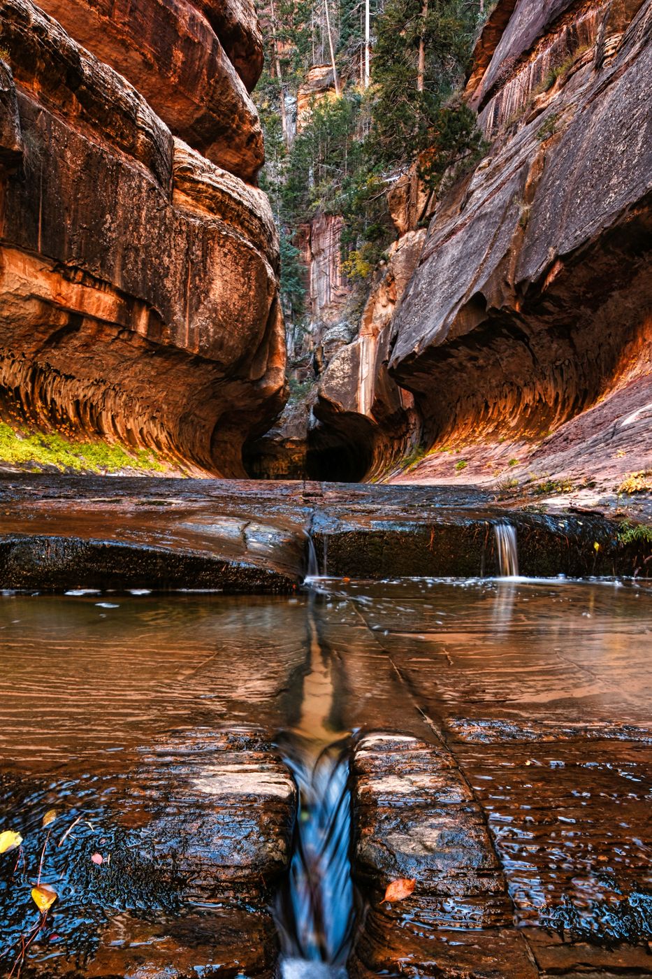
Try to carry a tripod. It's worth the extra weight and you’ll want it for the many cascades, waterfalls, and pools you’ll encounter. Also carry polarizing and ND filters. In the "Subway", there's a "waterfall chamber" that you can easily hear but can't see unless you wade through ice cold waist/chest deep water (so cold it instantly hurts) for about 20-30 feet. It's kind of a cool thing to do but I wouldn’t risk camera gear for what in my opinion wouldn’t be a very good picture. I tried and failed to get a decent shot but that’s just me. Watch for the dinosaur tracks that (as best that I can recall) are less than a mile up the creek (after you’ve made the initial climb down into the canyon). They're on a large gray/white block of rock on the side of the creek and are easy to miss if you’re not looking for them. If you want to photograph the famous “Archangel Falls” en route to the “Subway”, you’ll need to be there before mid morning to avoid harsh contrast issues.
Travel Information
From Springdale, drive south and west 14 miles to the town of Virgin. Turn right on the Kolob Road, sometimes called the Kolob Terrace road. The paved road climbs a dramatic ridge six and a half miles from Virgin, the road enters the park and three trailheads are soon encountered – the Right Fork, Grapevine Springs, then the Left Fork. Park at the Left Fork Trailhead. Mileage from the town of Virgin is about 8.6 miles. The driving time from Springdale is 45 minutes. There is a vault toilet at the trailhead. A park ranger frequently (perhaps always?) is parked at the trailhead to ensure hikers have the required permit and also to ensure that all registered hikers have made it back to the trailhead at the end of the day.
Spot Type
Outdoor
Crowd Factor
Nearly no other people
Best Timing
Sunrise in spring
Sunrise & Sunset
06:30 - 20:46
| current local time: 03:26
Photo Themes
Canyon
Rock Formation
Waterfalls and Cascades
Locations
Utah
Zion National Park


Spot comments (0)