
USA Vernal Fall Overlook
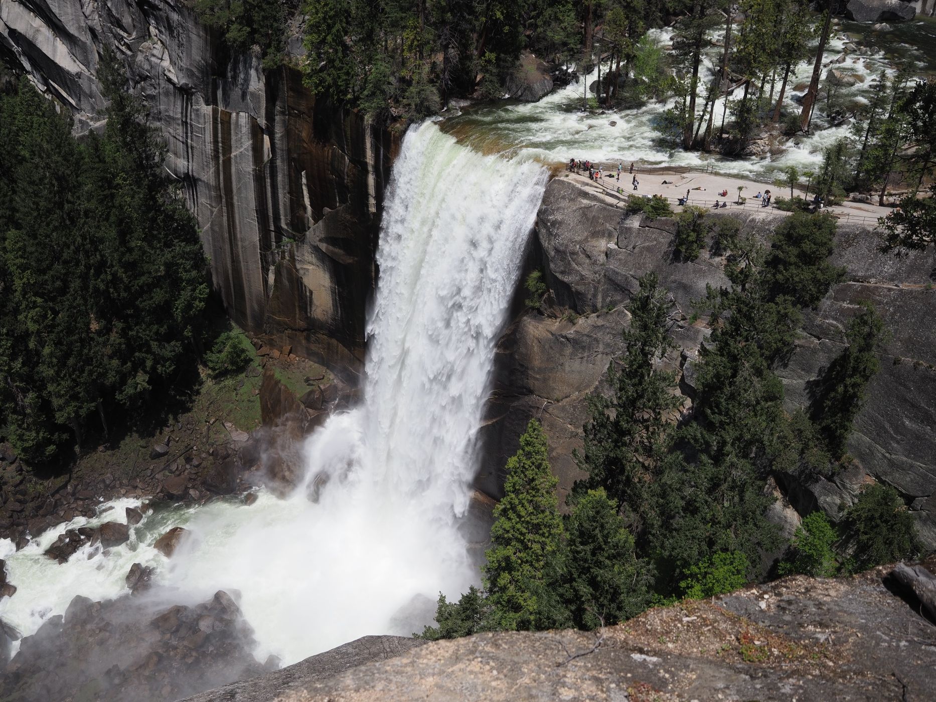
The Vernal Fall Overlook is my second favorite viewpoint in Yosemite after Glacier Point. However, this viewpoint has two distinct advantages over Glacier Point: (1) it is lightly visited and (2) it offers a better and far more intimate view of Vernal Fall. Go to Glacier Point for the grand sweeping vistas, but it will likely be crowded and Vernal Fall is a distant 1.6 mile/2.6 km away to the east. I have been to this overlook at least a half dozen times and each time I was the only person there until I invited passing hikers down to take a look (the viewpoint is easy to miss since it is a little bit off the trail).
BTW, the Vernal Fall Overlook is about 500 ft/152 m south of and 300 ft/100 m above the brink of Vernal Fall.
BTW, the Vernal Fall Overlook is about 500 ft/152 m south of and 300 ft/100 m above the brink of Vernal Fall.
Photography Tips
Vernal Fall faces southwest, so the best lighting is in the afternoon. Direct sunlight on the waterfall starts late morning, with the time varying by the season. I made this image on May 12, 2019, at 12:51 p.m.
Yosemite's waterfalls flow strongest from late winter through early summer, with the peak usually coming around mid-May. Some of Yosemite's waterfalls dry up in late summer, but not Vernal Fall and it's upstream companion, Nevada Fall. These two waterfalls are on the Merced River, which has a huge watershed, so they flow all year, although they do diminish in late summer.
I shoot Micro Four Thirds and framed this image at 17 mm (34 mm "full frame" equivalent). From this spot, I have gone as wide as 12 mm (24 mm equiv) and as long as 150 mm (300 mm equiv). I really like the telephoto view because when you frame the hikers standing at the brink with a small piece of the waterfall it emphasizes the power of the river going over the cliff.
Travel Information
This hike starts at Happy Isles in the east end of Yosemite Valley. In non-Covid years, the way to get to Happy Isles was simple and easy: park at any number of places in the east end of Yosemite Valley and ride one of the park's shuttle buses to Happy Isles. Happy Isles is just one of the many stops on the shuttle bus loop, and one of the more popular stops at that. I prefer to park at Curry Village because it minimizes time on the shuttle bus, which means more time for hiking.
Due to Covid, the shuttles haven't been running, so it's best to park in Curry Village (about a 1-mile/1.6-km walk from Happy Isles) or in the smaller hiker's parking lot about half way between Curry Village and Happy Isles. Either way, this part of the trail is nearly flat.
You pick up the Mist Trail on the east side of the Merced River, across from the shuttle bus stop. The short description of the hike is this: hike up the Mist Trail to the top of Vernal Fall, head upriver past Emerald Pool and along Silver Apron, then pick up the Clark Point Cutoff Trail. About halfway between where you left the Mist Trail and Clark Point is the Vernal Fall Overlook, just a few yards/meters off the trail. The overlook is easy to see from the trail, but it may not be obvious that it is the overlook. Zoom in on the satellite view so you can see where to look for it.
When you get to Clark Point you intersect with the John Muir Trail (JMT). From Clark Point, you can head back down the JMT to Happy Isles or you can head up the JMT to the top of Nevada Fall, like I did the day I took this image (May 12, 2019). The shorter and steeper way to get to Nevada Fall (and/or continue on to Half Dome) is to stay on the Mist Trail, but you will miss this viewpoint unless you specifically make a side trip. In general, hike UP the Mist Trail and hike DOWN the John Muir trail. Your knees will thank me. I also recommend shock absorbing trekking poles and knowing how to use them.
Carry water and snacks. Drinking water and the last flush toilets are found next to the bridge over the Merced River below Vernal Fall. Your first view of Vernal Fall is from the bridge. Pit toilets are available above Vernal Fall, near the Mist Trail/Clark Point Cutoff Trail junction. If you head up the Mist Trail to Nevada Fall, there are pit toilets where the Mist Trail intersects the John Muir Trail.
Please be aware that the Mist Trail is called that for a reason. In the spring there are two places along the trail where you are sure to get wet: as you approach Vernal Fall from below (this is the mist the trail is famous for) and, if you take the JMT to Nevada Fall, at an ephemeral cascade that drops right onto the trail. Many people carry ponchos for these two spots. I usually don’t (preferring to get wet to cool off), but I did in 2019. Also, my camera gear is fully weather sealed and I have hiked through these two spots for years with my camera out without a problem. But, if your gear is not fully weather sealed, I recommend “bagging” your camera to protect it. Where the trail is “misted” it can also be slippery, which is another reason to carry trekking poles and wear proper hiking boots. The first part of the Mist Trail is mostly paved and the upper sections are either dirt or constructed granite steps, many of which are quite tall. There are handrails or rock walls along certain parts of the trail, but not everywhere. Watch your footing.
Approximate distances and elevation changes:
Happy Isles to the top of Vernal Fall: 1.5 mi/2.4 km and 1,000 ft/300 m elevation gain.
Top of Vernal Fall to Vernal Fall Overlook: 0.3 mi/0.5 km and 300 ft/100 m elevation gain.
Vernal Fall Overlook to Clark Point: 0.2 mi/0.3 km and 250 ft/75 m elevation gain.
Clark Point to Happy Isles via the John Muir Trail: 2.2 mi/3.5 km and 1550 ft/475 m elevation loss.
For this route, I budget a half day (~4 hours for hiking, snacking, and photographing). When I go all the way to Nevada Fall, I budget a full day (~8 hours for hiking, snacking, lunch, and photographing).
For more information:
https://www.nps.gov/yose/planyourvisit/vernalnevadatrail.htm
https://www.alltrails.com/trail/us/california/vernal-falls-and-clark-point-via-mist-and-john-muir-loop
https://www.alltrails.com/trail/us/california/vernal-and-nevada-falls-via-the-mist-trail
https://www.myyosemitepark.com/things-to-do/hiking-trails/mist-trail/
https://www.yosemitehikes.com/yosemite-valley/mist-trail/mist-trail.htm
https://www.yosemite.com/what-to-do/the-mist-trail/
https://www.hikespeak.com/trails/mist-trail-yosemite/
Spot Type
Outdoor
Crowd Factor
Nearly no other people
Best Timing
Daytime in spring
Sunrise & Sunset
05:50 - 20:18
| current local time: 23:06
Photo Themes
Waterfalls
Locations
California
Yosemite National Park


Spot comments (0)