
USA Carlon Falls
Yosemite National Park is known for its towering waterfalls, led by world-famous Yosemite Falls (2,425 ft/740 m). But Yosemite also has dozens of small waterfalls that are worth visiting and many of these are little known outside of Central California, including 35-ft/11-m-tall Carlon Falls. In fact, I haven’t found a single mention of Carlon Falls on the park website. I suspect the reason for this is that the trailhead is just outside the park in the adjoining Stanislaus National Forest (SNF); and, it’s on their website that you will find a page about Carlon Falls and the modest hike to it (see Travel Information below). Since non-local visitors to Yosemite are not likely to check the SNF website while trip planning, Carlon Falls remains relatively obscure.
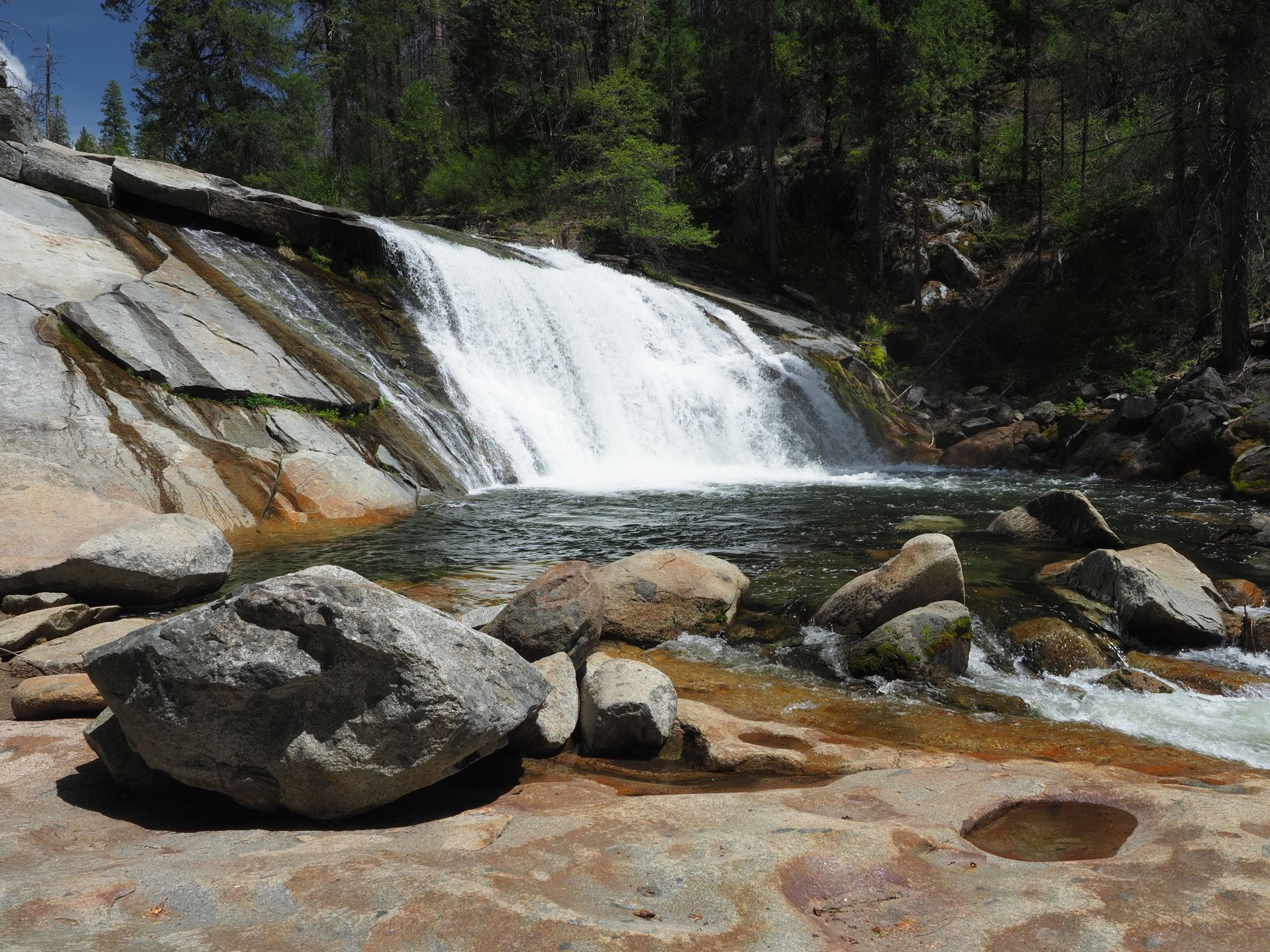
The oblique view of Carlon Falls shown here is from the north bank of the Tuolumne River near the edge of the falls’ plunge pool. There is a decent amount of room here to move around, so you can try different angles and foregrounds for your photographs. There are also some small cascades below the waterfall that are worth photographing. The trail continues upstream about 100 yards/90 m to just past the top of the falls. You can get different perspectives of the waterfall along the way, but there are trees that partially block some of these views. There is no trail on the south side of the river.
I have known about Carlon Falls for years, but only hiked it for the first time on May 16, 2020. My son and I wanted to do a day-hike in Yosemite, but the park was on full Covid lockdown at the time….well, almost full lockdown. It turns out that because the trailhead is outside the park, SNF had only limited lockdowns, and the trail dead-ends just past the waterfall, Carlon Falls was NOT on lockdown. We saw about two-dozen other people along the trail. Everyone kept their distances or pulled up their mask when needed. All-in-all, a very pleasant day.
The fall’s plunge pool and a couple smaller pools downstream are often used from late spring to late summer as swimming holes. The water is cold, but not too cold.
Photography Tips
Carlon Falls faces west-southwest and has a slightly sloped face, so the strongest lighting is from late morning to late afternoon. Because the waterfall is in the middle of a forest, it gets tree shadows on the south end probably all day and more tree shadows across the face beginning some unknown (to me) time before sunset. My son and I were at Carlon Falls from 12:00 p.m. to 2:30 p.m. so we had excellent lighting on the waterfall the entire time we were there.
I shoot Micro Four Thirds and framed this image using a 12-mm focal length (24-mm “full frame” equivalent). While at the waterfall, I used focal lengths ranging from a 4-mm circular fisheye (8-mm equiv.) to 150-mm (300-mm equiv.). I used the 4 mm for fun and 100 to 150 mm to isolate details. However, my favorite photographs from this hike are in the 7-mm to 20-mm range (14-mm to 40-mm equiv.).
For shutter speeds, I used a range of 1/8s (to get silky water) to 1/4000s (to get individual water drops). This image was shot in between at 1/200s. To use slow shutter speeds and get silky water, I suggest some combination of low ISO, and/or small aperture, and/or a neutral density filter. The In-body Image Stabilization in my Olympus E-M1 Mk II is more than adequate for handholding 1/8s and even longer. Had I brought a tripod, I might have tried multiple-second shutter speeds, but I prefer to hike without one. I bought an Olympus E-M1 Mk III not long after this hike and it has a Live ND mode that makes getting silky waterfalls handheld much easier.
Yosemite's waterfalls flow strongest from late winter through early summer, with the peak usually coming around mid-May. Some of Yosemite's waterfalls dry up in late summer, but not Carlon Falls. Carlon Falls is on the South Fork of the Tuolumne River, which has a huge watershed, so it flows all year, although it does diminish in late summer.
Travel Information
As the crow flies, the Carlon Falls trailhead is about 1.1 mi/1.8 km northeast of the Big Oak Flat Entrance Station into Yosemite National Park. The driving distance is not much longer.
The Big Oak Flat Entrance Station is on State Route 120. If you are coming to Yosemite from Northern California, you pick up SR 120 in Manteca if you are on SR 99, south of Lathrop if you are on Interstate 5, or east of Tracy if you are coming from the San Francisco area. If you are already in Yosemite National Park, just head to the Big Oak Flat Entrance Station where the following directions start. If you are coming from another direction, there are too many options to describe here.
So, if starting from the Big Oak Flat Entrance Station, head north on SR 120 about 1.1 mi/1.8 km and turn right (east) onto Evergreen Road. If you are coming in on SR 120 from the west, turn left (east) onto Evergreen Road 1.1 mi/1.8 km before getting to the entrance station. From this intersection, which is signed as the route to Hetch Hetchy, drive generally east about 0.8 mi/1.3 km to Carlon Forest Service Station and Carlon Campground. Here, Evergreen Road crosses the Tuolumne River on a wide bridge, as it makes a turn to the north. Just before the bridge, a narrow road on the left (north) side of Evergreen Road leads a couple hundred yards/meters to the Carlon Forest Service Station, which has parking, picnic tables, pit toilets, and a nice view of the river. The campground (which is opposite the Forest Service Station on the right/south side of Evergreen Road) requires reservations, so don’t try to park there. There is a limited amount of parking at the trailhead, which is at the north end of the bridge.
The hike is about 1.6 mi/2.6 km one-way, or 3.2 mi/5.2 km out-and-back. The elevation gain from the trailhead to the base of the waterfall is about 250 ft/75 m. Add a little more distance and a little more elevation gain to get to the top of the waterfall and/or if you park at the Carlon Forest Service Station.
You reach the national park boundary about 250 yds/230 m from the trailhead. At this point there is a tight little maze in the fence that is designed to keep bicycles and horses off the trail. From there, the trail is mostly easy. At about 1.2 mi/1.9 km from the trailhead, there is a short (maybe 30-ft/10-m high) steep section of trail. Also in this area and just beyond are various use trails that parallel the official trail, so it’s easy to be on the wrong one. However, you can’t really get lost because you are paralleling a river in a narrow valley (I hesitate to call it a canyon).
The Carlon Falls trailhead is at elevation of about 4,325 ft/1,320 m, so it gets snow in the winter. However, I have seen many photographs of Carlon Falls with some snow around it, so the trail is probably navigable all year except during a snow storm.
For more information:
https://www.fs.usda.gov/recarea/stanislaus/recarea/?recid=79362
https://www.yosemitehikes.com/hetch-hetchy/carlon-falls/carlon-falls.htm
https://www.alltrails.com/trail/us/california/carlon-falls-trail
https://www.hikingproject.com/trail/7009261/carlon-falls-trail
https://www.world-of-waterfalls.com/waterfalls/yosemite-carlon-falls/
Carlon Falls (called “Falls”), Big Oak Flat Entrance Station and nearby Hogdon Meadow Campground, Carlon Forest Service Station, Carlon Campground, and the entire trail are shown on the Ackerson Mountain 7.5-minute Quadrangle. A PDF version of this topographic map can be downloaded from here: https://ngmdb.usgs.gov/topoview/viewer/#14/37.8081/-119.8591 I suggest downloading the 2001 version of the map because the newer versions don’t show the waterfall, only the trail to it (to my great dismay, recent USGS topographic maps show far fewer waterfalls than the older maps). In the past, I have used the USGS store ( https://store.usgs.gov/map-locator ) to download quads, but the portion of the site where you download maps was off-line for maintenance when I wrote this. I don’t know if USGS site above will supersede the USGS store or if it will operate alongside it. However, for sheer convenience, I use the Topo Maps app on my iPhone. I have downloaded all 2,700 or so 7.5-minute quads that cover California, plus a few hundred other quads for selected locations in other states.
Spot Type
Outdoor
Crowd Factor
Just a few people
Best Timing
Daytime in spring
Sunrise & Sunset
05:51 - 20:19
| current local time: 11:27
Photo Themes
Waterfall
Locations
California
Yosemite National Park


Spot comments (0)