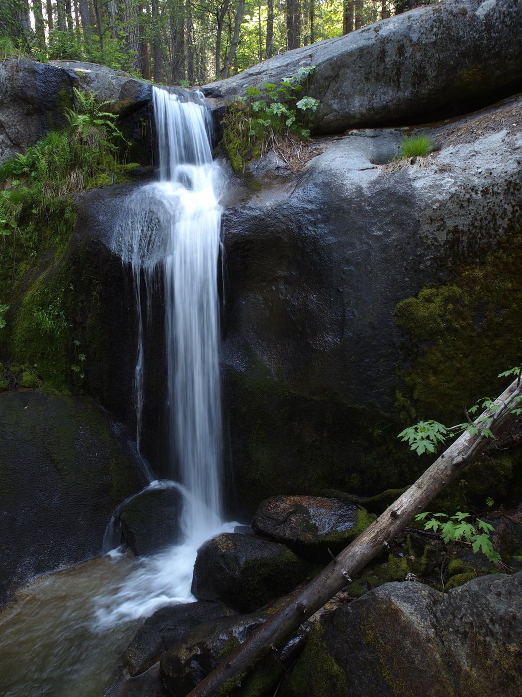

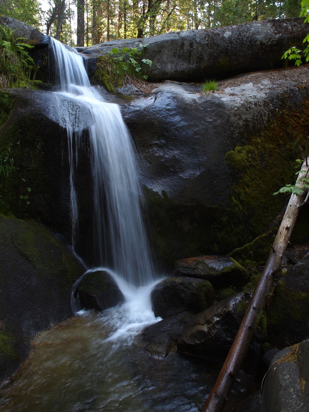
USA Little Nellie Falls
Yosemite National Park is known for its towering waterfalls, led by world-famous Yosemite Falls (2,425 ft/740 m). But the Yosemite region also has dozens of small waterfalls that are worth visiting and many of these are little known outside of Central California, including 15-ft/4.5-m-tall Little Nellie Falls. Little Nellie Falls is actually in the Stanislaus National Forest, just outside the western boundary of the park, but the easiest route to get there is through the park.
Little Nellie Falls is technically a drive-to waterfall that is only a couple dozen yards/meters from the road, but its only drive-to when Old Coulterville Road west of the community of Foresta is open to traffic. When I drove this route in my Jeep in 2012, the road was open and it was clearly not suited for passenger cars. On the other hand, my stock Grand Cherokee had no difficulties. Otherwise, it’s a 5.6-mi/9.0-km out-and-back hike from Foresta. I have visited Little Nellie Falls only once and I had it to myself. In fact, I saw no other vehicles on the road between Foresta and the waterfall.
While most of Yosemite’s waterfalls provide awesome displays of power, especially in the spring, Little Nellie Falls is small and delicate and is set in a pretty niche in the forest. Just across the road is a very nice picnic table with a memorial plaque on the legs. At least one of the website listed below under Travel Information shows the table and plaque.
Photography Tips
Little Nellie Falls faces southeast, but it’s deep in the forest, so sunlight is hit and miss. Any sunlight that hits the falls will be in the morning. This image from May 2012 was made just before 4:30 p.m.
I shot an Olympus E-5 at the time (Four Thirds) and framed this image using a 12-mm focal length (24-mm “full frame” equivalent) and a shutter speed of 1/5s. To use slow shutter speeds and get silky water, I suggest some combination of low ISO, and/or small aperture, and/or a neutral density filter.
Yosemite's waterfalls flow strongest from late winter through early summer, with the peak usually coming around mid-May. Some of Yosemite's waterfalls dry up in late summer. I have only visited Little Nellie Falls in the spring, so I don’t know how it fares in the summer. Its watershed is not very big, but it’s virtually all forest, so I suspect Little Nellie Falls diminishes in late summer but doesn’t completely dry up.
Travel Information
The community of Foresta is on Old Coulterville Road, which branches south off Big Oak Flat Road between Crane Flat (which is also the western end of Tioga Road) and Yosemite Valley, but closer to Yosemite Valley than to Crane Flat. Outside the park to the west, Big Oak Flat Road is also State Route 120. The trailhead for Little Nellie Falls (if you must hike) is on the north end of Foresta. The websites below include directions and trail descriptions. If and when the road is open, the drive is the same route as the hike.
Please note that the road to Little Nellie Falls (Old Coulterville Road) passes through the small private enclave community of Foresta, most of which burned in a fire in 1991 and little of which has been rebuilt. The road is sometimes closed to traffic past Foresta and possibly even to hikers depending on its condition. My visit in 2012 was along a bumpy, poorly graded road best suited for high-clearance vehicles.
https://www.yosemitehikes.com/hetch-hetchy/little-nellie-falls/little-nellie-falls.htm
https://caltopo.com/m/KG0L
https://sierranewsonline.com/hiking-on-the-old-coulterville-road-to-little-nellie-falls/
https://sierranewsonline.com/hiking-to-little-nellie-and-foresta-falls/
https://califraven.com/tag/stanislaus-national-forest/
Little Nellie Falls, the community of Foresta, and the entire road/trail from the north end of Foresta are shown on the El Portal 7.5-minute Quadrangle. A PDF version of this topographic map can be downloaded from here: https://ngmdb.usgs.gov/topoview/viewer/#15/37.6999/-119.7541 I suggest downloading either or both the 2004 version of the map (an older style mapping that I find easier to read) or the 2018 version (which is the most current). I suggest also downloading the adjoining El Capitan quad (https://ngmdb.usgs.gov/topoview/viewer/#12/37.7367/-119.6355) for the same years as the El Portal quad. The El Capitan quad shows the intersection of Big Oak Flat Road and Old Coulterville Road.
In the past, I have used the USGS store ( https://store.usgs.gov/map-locator ) to download quads, but the portion of the site where you download maps was off-line for maintenance when I wrote this. I don’t know if USGS site above will supersede the USGS store or if it will operate alongside it. However, for sheer convenience, I use the Topo Maps app on my iPhone. I have downloaded all 2,700 or so 7.5-minute quads that cover California, plus a few hundred other quads for selected locations in other states.
Spot Type
Outdoor
Crowd Factor
Nearly no other people
Best Timing
Daytime in spring
Sunrise & Sunset
05:51 - 20:18
| current local time: 17:47
Photo Themes
Waterfall


Spot comments (0)