
USA Garlic Falls Viewpoint
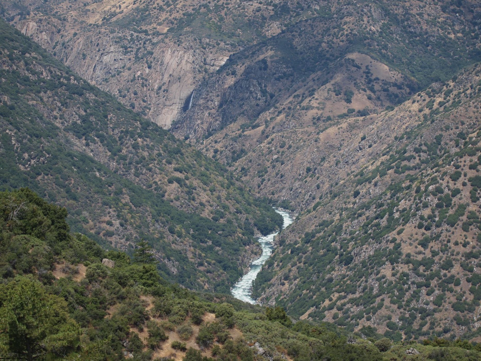
The spot is an unmarked turnout on California State Highway 180 in the Giant Sequoia National Monument, between the Grant Grove and Cedar Grove sections of Kings Canyon National Park. The goal here is to catch a distant glimpse of part of 820-ft-tall (250 m) Garlic Falls. There is at least one other nearby turnout where you can also see Garlic Falls, but this spot has the better view. A little further one way or the other along the highway and some piece of topography will intervene and block your view of the waterfall. Most people drive by this spot blissfully unaware that a nice waterfall is posing in the distance. Don’t be most people.
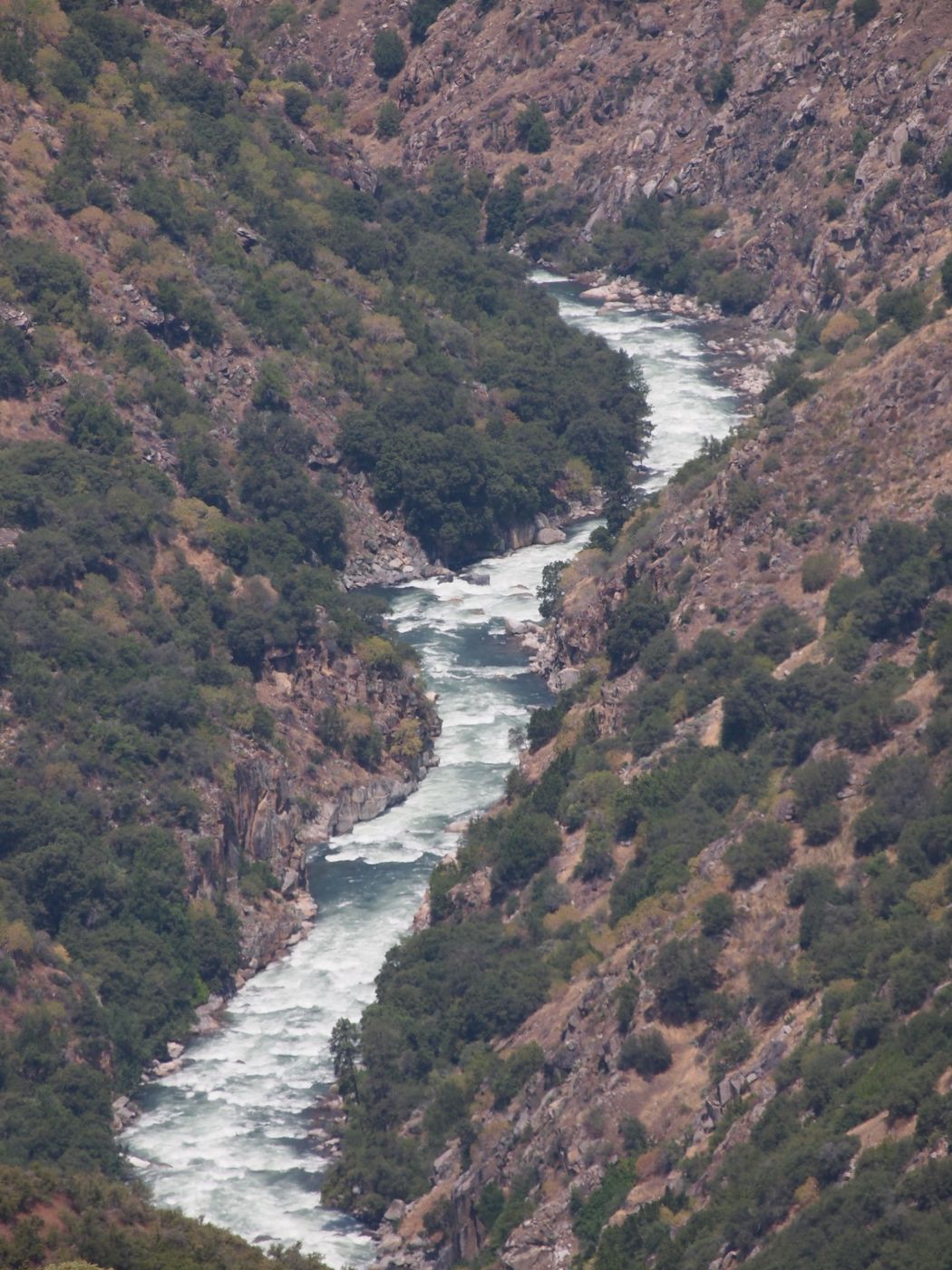
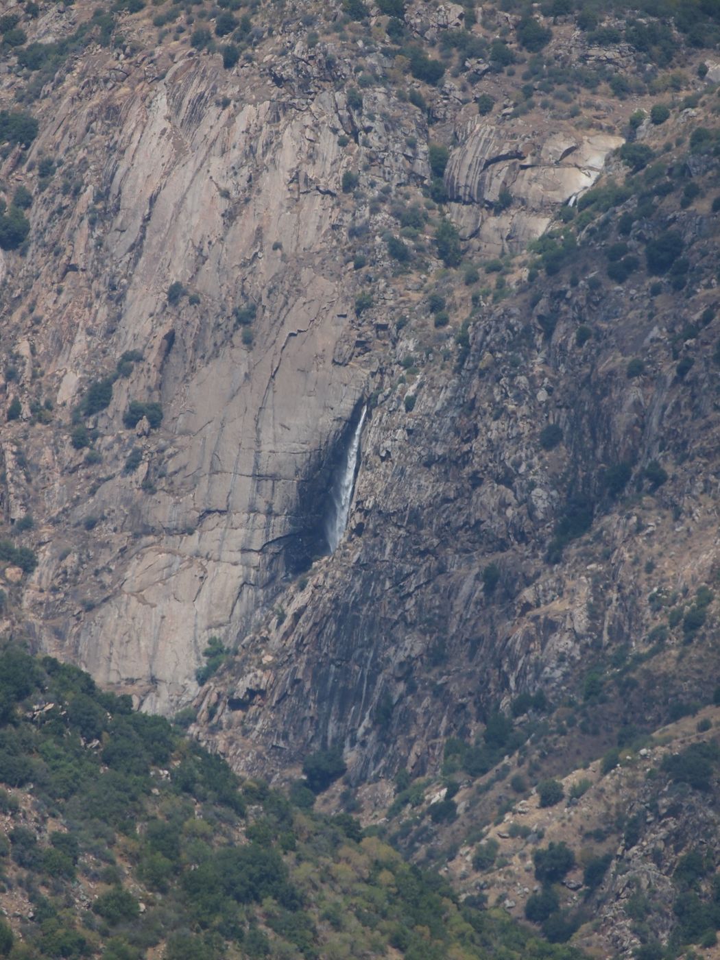
From this spot, Garlic Falls is 3.45 mi (5.55 km) away at an azimuth of about 306° (i.e., just shy of northwest). Unless you have superb vision, I suggest using binoculars to find the waterfall. This spot has an elevation of about 4,800 ft (1,460 m), so it can be warm in the summer. The visible brink of Garlic Falls (there is a hidden drop above the visible drop) has an elevation of about 2,200 ft (670 m). The Kings River below the waterfall has an elevation of about 1,700 ft (520 m).
This section of the Kings River Canyon is one of the deepest river gorges in North America, measuring about 7,900 ft (2,400 m) from the top of Spanish Mountain to the Kings River directly below. Some sources claim a depth of 8,200 ft, but the topographic maps don’t agree. Spanish Mountain has an elevation of 10,051 ft (3,064 m) and is the tallest peak on the ridge line north of the river. The azimuth from this spot to Spanish Mountain is about 6°, so almost due north.
Photography Tips
I estimate that about 200 feet (60 m) of the waterfall is visible from this spot. If so, then it subtends only about 0.6° (trigonometry is wonderful). This is clearly telephoto territory and I recommend a polarizing filter as well.
I made these three images of Garlic Falls and the Kings River using an Olympus E-5 and a 50-200 f/2.8-3.5 lens plus a 1.4x teleconverter. The Four-Thirds sensor has a 2x frame factor compared to 35 mm, so the equivalent focal lengths for this setup was 140 mm to 566 mm. The widest photo (waterfall and river) was at 140 mm equivalent and the two narrower photos (one for the waterfall and one for the river) were at 566 mm equivalent. I also tried my 500-mm manual focus mirror lens (1,000 mm equivalent), but those photos are a little mushy so I won’t be posting them.
Like many Sierra Nevada waterfalls, the flow over Garlic Falls peaks around May or June, depending on the snow pack from the previous winter. Because Garlic Falls has a steep and rocky watershed of only modest size--perhaps covering only about 10 square miles (26 square km)--by mid-summer it is usually down to trickle. So, if you want to be the only person you know who has seen Garlic Falls, your best bet is springtime.
Also, don’t neglect the Kings River Canyon itself. All along the drive between Grant Grove and Cedar Grove are interesting views of the canyon walls, the river, the local geology, etc., which means lots of photo opportunities. Down in the bottom of the canyon further east is a show cave (Boyden Cavern) and a roadside waterfall (Grizzly Falls) and then you get into the Cedar Grove section of Kings Canyon National Park. More photo spots for this area are coming up.
Travel Information
This spot is easy to get to. From the Visitor Center in Grant Grove Village in Kings Canyon National Park, drive almost exactly 10.0 miles (16.1 km) to the north/northeast and park in the turnout. This turnout is on the opposite side of the road if you are coming from Grant Grove, so be careful of oncoming traffic. Fortunately, the turnout is wide enough for you to make this turn and large enough for several cars. Per Google Earth, the better turnout has the following latitude and longitude: 36.833722°N, 118.900675°W (WGS84). The other turnout, which is shorter and narrower, has the following coordinates: 36.833205°N, 118.901860°W (WGS84). These two turnouts are only about 400 ft (120 m) apart, so you might want to stop at both.
There is technically a trail to the top of Garlic Falls, but it starts far to the west and is not for the inexperienced. See the YouTube video listed below for an expedition that hiked to Garlic Falls.
Please note that this section of Hwy 180 is closed in the winter just past the turnoff for Hume Lake Road. Hume Lake and Hume Lake Road are open all year. The other way into Hume Lake (Ten Mile Road) is closed in the winter from Quail Flat on the Generals Highway (Hwy 198) to the lake. Hume Lake is a great place to visit as well. On the north side of the lake is a Forest Service campground. On the west end of the lake is a Christian camp and private cabins, along with a gas station, a burger restaurant, a small market, etc. At the east end of the lake is a swimming area with a beach called Sandy Cove Day Use Area.
Finally, if you have a high-clearance vehicle, the nearby Converse Basin Grove is worth visiting. One of the dirt roads in the grove will get you the Boole Tree trailhead. The Boole Tree is the 6th largest Giant Sequoia and is reached via a moderate 2.5 mile (4.0 km) loop hike from the trailhead. The hike can be dusty in the summer. A different dirt road will get you to the Chicago Stump trailhead. The Chicago Stump was cut for the 1893 World’s Columbian Exposition in Chicago (hence the name) and is an easier 0.6 mi (1.0 km) out and back hike.
For more information about Garlic Falls.
https://www.worldwaterfalldatabase.com/waterfall/Garlic-Falls-441
https://www.youtube.com/watch?v=9OWIwbUSthI&t=793s
If you’re into whitewater, you can let the Kings River take you past the base of Garlic Falls and a few other minor falls as well. I don’t know if there are outfitters who cover this part of the river, so this might be a do-it-yourself expedition.
https://brexpeditions.com/california/upper-kings/
http://www.awetstate.com/KingsGF.html
https://cacreeks.com/kingsgf.htm
Here is some information about the Giant Sequoia National Monument.
https://en.wikipedia.org/wiki/Giant_Sequoia_National_Monument
https://www.fs.usda.gov/detail/sequoia/home/?cid=stelprdb5394941
https://www.fs.usda.gov/visit/destination/giant-sequoia-national-monument-0
https://www.fs.usda.gov/main/sequoia/maps-pubs
https://www.nps.gov/seki/planyourvisit/maps.htm
Here is some information about Hume Lake.
https://en.wikipedia.org/wiki/Hume_Lake
https://www.fs.usda.gov/recarea/sequoia/recarea/?recid=79939
https://hume.org/
Here is some information about the Converse Basin Grove.
https://en.wikipedia.org/wiki/Converse_Basin_Grove
https://www.fs.fed.us/r5/sequoia/gsnm/gsnm-boole-tree.html
https://www.fs.usda.gov/recarea/sequoia/recarea/?recid=79586
https://www.fs.usda.gov/recarea/sequoia/recarea/?recid=79595
Spot Type
Outdoor
Crowd Factor
Nearly no other people
Best Timing
Daytime in spring
Sunrise & Sunset
05:50 - 20:13
| current local time: 17:45
Photo Themes
Canyon
Waterfall


Spot comments (0)