
USA Kings River Canyon
Between the Grant Grove and Cedar Grove sections of Kings Canyon National Park, California State Highway 180 passes through the Giant Sequoia National Monument, although you will see precious few giant sequoias along this stretch of highway (the individual groves are on dirt side roads or must be reached on foot). This spot is labeled as “Junction View Overlook” on the official National Park Service map of Sequoia and Kings Canyon National Parks and on the USGS Wren Peak Quadrangle (7.5-minute topographic map).
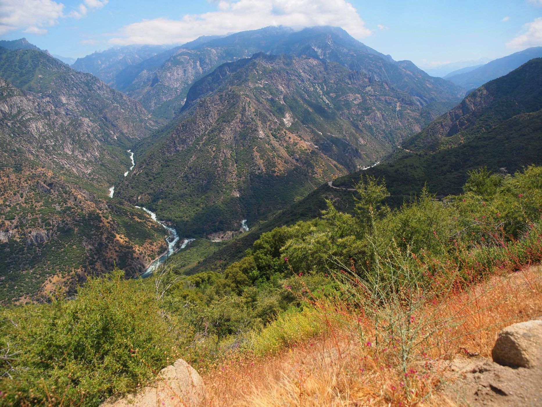
From this spot—in the direction shown—you can see the confluence of the South Fork and the Middle Fork of the Kings River, their canyons, and the Monarch Divide ridge in between. To understand the size of these canyons, consider the following. This spot is at an elevation of 4,490 ft (1,370 m); the river confluence is at an elevation of 2,250 ft (585 m); and, Eagle Peaks (the tallest peak in the upper-middle background) has an elevation of 9837 ft (2,998 m).
While you are here, take in the rest of the view. This spot feels very remote, and yet you are not far from what we call civilization.
Photography Tips
This is landscape photography on a large scale and justifies everything from wide angle to telephoto lenses, and even making panoramas. A polarizer will be helpful.
Travel Information
From the Visitor Center in Grant Grove in Kings Canyon National Park, drive 10.7 miles 17.2 km) north/northeast to a large turnout on the other side of the road. This turnout is on a hairpin curve, so watch for oncoming traffic while turning into the turnout.
Please note that this section of Hwy 180 is closed in the winter just past the turnoff for Hume Lake Road. Hume Lake and Hume Lake Road are open all year. The other way into Hume Lake (Ten Mile Road) is closed in the winter from Quail Flat on the Generals Highway (Hwy 198) to the lake. Hume Lake is a great place to visit as well. On the north side of the lake is a Forest Service campground. On the west end of the lake is a Christian camp and private cabins, along with a gas station, a burger restaurant, a small market, etc. At the east end of the lake is a swimming area with a beach called Sandy Cove Day Use Area.
Finally, if you have a high-clearance vehicle, the nearby Converse Basin Grove is worth visiting. One of the dirt roads in the grove will get you the Boole Tree trailhead. The Boole Tree is the 6th largest Giant Sequoia and is reached via a moderate 2.5 mile (4.0 km) loop hike from the trailhead. The hike can be dusty in the summer. A different dirt road will get you to the Chicago Stump trailhead. The Chicago Stump was cut for the 1893 World’s Columbian Exposition in Chicago (hence the name) and is an easier 0.6 mi (1.0 km) out and back hike.
Here is some information about the Giant Sequoia National Monument.
https://en.wikipedia.org/wiki/Giant_Sequoia_National_Monument
https://www.fs.usda.gov/detail/sequoia/home/?cid=stelprdb5394941
https://www.fs.usda.gov/visit/destination/giant-sequoia-national-monument-0
https://www.fs.usda.gov/main/sequoia/maps-pubs
https://www.nps.gov/seki/planyourvisit/maps.htm
Here is some information about Hume Lake.
https://en.wikipedia.org/wiki/Hume_Lake
https://www.fs.usda.gov/recarea/sequoia/recarea/?recid=79939
https://hume.org/
Here is some information about the Converse Basin Grove.
https://en.wikipedia.org/wiki/Converse_Basin_Grove
https://www.fs.fed.us/r5/sequoia/gsnm/gsnm-boole-tree.html
https://www.fs.usda.gov/recarea/sequoia/recarea/?recid=79586
https://www.fs.usda.gov/recarea/sequoia/recarea/?recid=79595
Spot Type
Outdoor
Crowd Factor
Just a few people
Best Timing
Daytime in spring
Sunrise & Sunset
05:50 - 20:13
| current local time: 23:58
Photo Themes
Canyons
Rivers
scenery


Spot comments (0)