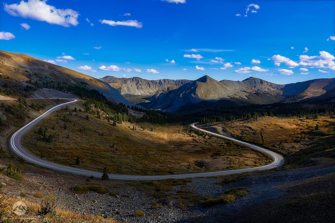

USA Cottonwood Pass
Cottonwood Pass summit, Colorado. Elevation 12,126 feet, one of the highest paved passes in the state, straddling the Sawatch Range on the Continental Divide between Buena Vista and Taylor Park. The top opens into wide alpine tundra with sweeping views of the Collegiate Peaks to the west and rolling high country to the east. Wind is near constant up here and temperatures drop fast, even in summer. A short walking trail from the parking area leads out along the ridge for a clean, unobstructed shot in most directions. Best light comes early morning or near sunset, and the road typically closes with snow from late fall through spring.
Photography Tips
Shoot early morning or right at sunset. Midday light flattens the tundra and mountains, and you lose the depth in the Collegiate Peaks.
Use a wide angle lens, something in the 16 to 24mm range works well up there, to capture the scale of the ridge line and the sky at once. A polarizer helps cut glare and pull more contrast out of the sky and distant peaks.
Bring layers and expect wind. At 12,126 feet the gusts up top can shake a tripod loose or blur a long exposure, so weigh your tripod down or shoot at a faster shutter speed than you normally would.
Watch the weather closely. Storms build fast over the Divide in summer afternoons, so plan to be up there and back down before early afternoon if you're chasing clear skies, or go right at golden hour when storm cells usually clear out.
For foreground interest, look for tundra grasses, wildflowers in July, or scattered rock outcrops near the ridge trail. They give the wide shots something to anchor on instead of just sky and distant peaks.
If you want fall color, shoot the aspens lower on the pass road on the way up or down rather than at the summit itself, since the top sits above tree line.
And if you're after stars or the Milky Way, the exposed ridge with no trees blocking the horizon makes it a strong spot, just get there well before dark since the road has no lighting and the drop offs are real.
Use a wide angle lens, something in the 16 to 24mm range works well up there, to capture the scale of the ridge line and the sky at once. A polarizer helps cut glare and pull more contrast out of the sky and distant peaks.
Bring layers and expect wind. At 12,126 feet the gusts up top can shake a tripod loose or blur a long exposure, so weigh your tripod down or shoot at a faster shutter speed than you normally would.
Watch the weather closely. Storms build fast over the Divide in summer afternoons, so plan to be up there and back down before early afternoon if you're chasing clear skies, or go right at golden hour when storm cells usually clear out.
For foreground interest, look for tundra grasses, wildflowers in July, or scattered rock outcrops near the ridge trail. They give the wide shots something to anchor on instead of just sky and distant peaks.
If you want fall color, shoot the aspens lower on the pass road on the way up or down rather than at the summit itself, since the top sits above tree line.
And if you're after stars or the Milky Way, the exposed ridge with no trees blocking the horizon makes it a strong spot, just get there well before dark since the road has no lighting and the drop offs are real.
Travel Information
Cottonwood Pass, Colorado. Elevation 12,126 feet, between Buena Vista and Taylor Park on County Road 306.
Paved on the Buena Vista side, gravel on the Taylor Park side. Fine for a regular car in good weather.
Closes for winter on November 3, reopens late May. No gas, food, or cell service up there, so plan ahead. Afternoon storms build fast, so check conditions before you go.
Paved on the Buena Vista side, gravel on the Taylor Park side. Fine for a regular car in good weather.
Closes for winter on November 3, reopens late May. No gas, food, or cell service up there, so plan ahead. Afternoon storms build fast, so check conditions before you go.
Spot Type
Outdoor
Crowd Factor
A decent amount of people
Best Timing
Sunrise in summer
Sunrise & Sunset
07:01 - 18:48
| current local time: 20:10
Photo Themes
Landscape
Long Exposure
Mountainscape
Travel Photography
Locations
Colorado
Rocky Mountains
cottonwood pass





Spot comments (0)