
Known as one of the most demanding long-distance hikes in the world, the Haute Route cuts through some of the most awe-inspiring landscapes of the French and Swiss Alps. We weren’t just chasing dramatic views; we wanted to immerse ourselves in alpine culture, breathe in the history of these mountains, and push our own limits in a way we had never done before.
Surrounded by lush green alpine valleys scattered with wildflowers, glaciers clinging impossibly to the faces of towering 4,000-meter peaks, and Europe’s legendary giants - Mont Blanc and the Matterhorn - the Haute Route quickly became one of the most exhilarating journeys we have ever taken.
Preparing for the Haute Route
To be honest, this trek is not for the faint-hearted. You don’t need to be a professional mountaineer, but you do need to be fit, mentally prepared, and ready for long days on your feet. In the months leading up to the hike, we trained consistently - sometimes with our backpacks, sometimes without - and worked on our mindset for the nine days ahead. Luckily, you don’t need to carry too much gear, as the route is lined with remote mountain huts and charming village hotels. Still, preparation is key: every day demands at least 1,000 meters of elevation gain and an average of 15 kilometers of hiking.
We arrive in Chamonix in the afternoon on the day before the hike and are greeted by sunshine. We stroll through Chamonix, eat Fondue and Tarte di Flete, walk around the town, and take photos of whatever catches our eye. It's nice to be here. The next day, we prepare ourselves mentally for the hike until it's finally time to set off.

Get the exact geo-position for this spot: Mont Blanc View Chamonix
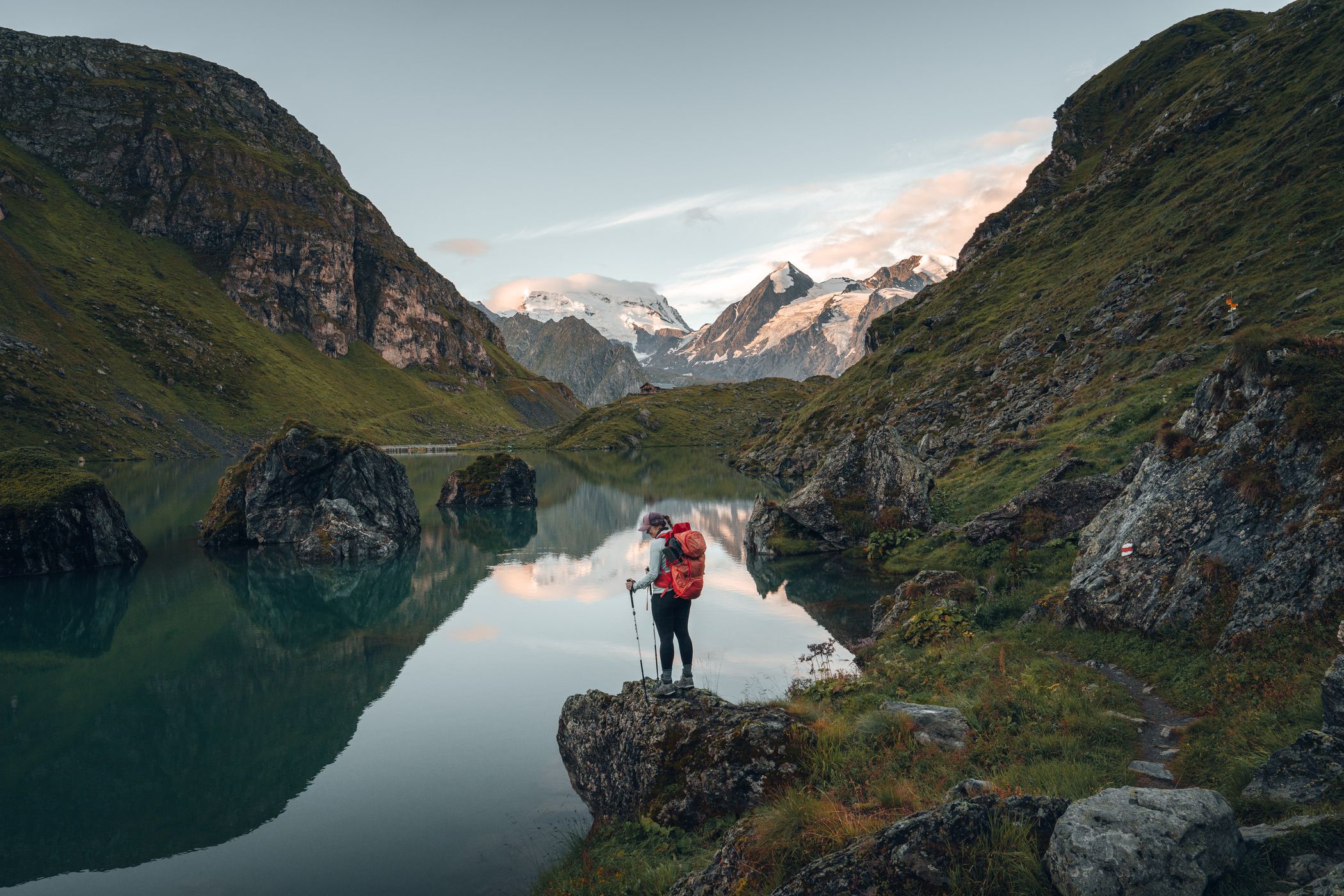
Day 1 - Chamonix to Trient
Distance: 15 km | Ascent: 1,130 m | Descent: 1,230 m

Get the exact geo-position for this spot: Montroc View
Our first day quickly becomes one of our absolute favorites. Before sunrise, we board an early train to Montroc, shouldering our packs as the village slowly wakes up. From the very first steps, the trail climbs steeply through dense, shadowy forest, the only sounds our breathing and the crunch of boots on the path. After around 800 meters of ascent, the trees suddenly give way. The landscape opens up, and Mont Blanc reveals itself in all its grandeur, glowing softly in the morning light - a moment that stops us in our tracks. From here, the trail leads us past the Aiguillette des Posettes, the highest point of the day, offering sweeping panoramic views that make every step uphill feel worthwhile.

Get the exact geo-position for this spot: Aiguillette des Posettes
A short descent follows before we cross a small summit that quietly marks the border into Switzerland. The atmosphere shifts as the trail winds through a wide, open valley, with vast views stretching in every direction - rugged peaks, rolling alpine meadows, and a sense of freedom that only the mountains can give. Before we head down to Trient, we pass by a beautiful hut with amazing views, enjoying our last drinking break before heading down.

Get the exact geo-position for this spot: Mountain hut
Gradually, the path leads us down into the charming village of Trient, our first real taste of Swiss mountain life. In this small village, we find our first accommodation of the trip and are lucky enough to have an entire dorm just for the three of us. We end the day exactly the way it should be ended: with a hearty pot of potato and cheese fondue - simple, comforting, and exactly what our hungry bodies had been craving.

Get the exact geo-position for this spot: Charming village of Trient
Day 2 - Trient to Champex
Distance: 15 km | Ascent: 1,000 m | Descent: 830 m
Two routes lead from Trient to Champex - one more technical, even crossing a glacier, and one more moderate. We opt for the easier option and start the day weaving through quiet forest trails, slowly gaining elevation until the trees thin out and the landscape opens into alpine meadows bursting with wildflowers. After the first long climb, we reach the Col de la Forclaz.

Get the exact geo-position for this spot: Col de la Forclaz in Rays
Standing on the pass feels like a small victory - a natural pause where the view stretches wide, and the effort of the ascent suddenly makes sense. From here, the trail softens, rolling gently through open terrain before leading us toward the highest point of the day. There, a tiny mountain hut awaits us, perfectly placed in the landscape. Hot coffee and homemade cake taste unreal after the climb, and a group of curious Swiss cows wanders over, inspecting us with calm interest. It’s one of those unplanned moments that quietly becomes a highlight - simple, unexpected, and impossible to forget.

Get the exact geo-position for this spot: Alpine Cows
Bathed in bright afternoon light, we make our way down toward Champex, quietly grateful that this time the trail leads downhill rather than up. Champex, often nicknamed “Little Canada,” rests peacefully beside its lake, framed by forested slopes and calm alpine air. After dinner - once again, cheese fondue - we spend the evening by the water’s edge, watching the village lights shimmer across the perfectly still, mirror-like surface. Pure magic.
Day 3 - Champex to Cabane de Mille
Distance: 19 km | Ascent: 1,750 m | Descent: 750 m
This will be one of the toughest days of the entire trek, so we leave early - long before the trail begins to climb. At sunrise, Champex Lake lies completely still, the surface smooth like glass. The surrounding trees, chalets, and mountains are reflected so perfectly that it’s hard to tell where reality ends and its mirror image begins. We take our time here. Walking slowly along the shore, adjusting angles, waiting for the light to change just enough. The small wooden boat resting on the lake becomes our favorite subject - floating quietly between two worlds, perfectly framed by its own reflection. It’s one of those rare moments where everything aligns, and photography feels effortless. An image straight out of a dream.

Get the exact geo-position for this spot: Champex Lac Boats
Eventually, we turn away from the lake and begin the long descent to Orsières. The contrast is sharp: from stillness to movement, from calm reflections to steep forest paths. In Orsières, we take a short break, warming our hands around a coffee before heading back uphill.

Get the exact geo-position for this spot: Valley Village
From here, the real challenge begins. The climb toward Mont Brulé is relentless - brutally steep and uncomfortably long. Yet with every step, the views grow wider and more dramatic, pulling us higher into the landscape. We stop for lunch halfway up in a small village called Commeire, sharing the moment with grazing cows and soaking in the scenery before pushing on.

Get the exact geo-position for this spot: Commeire Mountain View
At the summit, at 2,572 meters, we do not stand in silence- we cheer ourselves and are very happy we made it. The Alps stretch endlessly in every direction - a full 360° panorama that leaves us speechless and will stay with us forever.
Our hut for the night, Cabane de Mille, sits close to the peak. A well-earned dinner waits for us, paired with a view so vast and unreal that it feels like the perfect reward after one of the hardest - and most memorable - days of the journey.
Day 4 - Cabane de Mille to Cabane de Louvie
Distance: 18 km | Ascent: 1,200 m | Descent: 1,510 m
The weather turns moody today - low clouds, shifting fog, soft diffused light. The dramatic skyline disappears, replaced by a mysterious, almost cinematic atmosphere that makes the landscape feel alive. Shortly after we depart Cabane de Mille, we reach Col de Mille, which is covered in clouds.

Get the exact geo-position for this spot: Moody Col de Mille
We hike through the misty landscape, taking lots of photos of huts and plants along the way, and the camera clicks away as if it were sunrise.

Get the exact geo-position for this spot: Moody mountain hut
We refuel at Cabane Brunet with their famous Brunet macaroni and apricot cake - both absolute musts - before continuing toward Cabane de Louvie. As we descend toward Fionnay, the clouds finally open, revealing massive glaciers clinging to steep rock walls. The route takes us past one of Switzerland’s most underrated waterfalls and ends at the serene Lac de Louvie.

Get the exact geo-position for this spot: Waterfall in Fionnay
But to reach Louvie, we have to climb up again, leaving Fionnay in the valley behind us. Up here, we get one of the most rewarding views - the lac de Louvie in front of glaciers, with little flowers in front. Feels like straight out of a fairytale!

Get the exact geo-position for this spot: Lac de Louvie with flowers
Cabane de Louvie becomes our favorite hut of the entire trek - breathtaking views, delicious food, and a team that treats hikers like family.

Get the exact geo-position for this spot: Cabane de Louvie view
Day 5 - Cabane de Louvie to Cabane de Prafleuri
Distance: 14 km | Ascent: 1,070 m | Descent: 1,645 m

Get the exact geo-position for this spot: Cabane de Louvie
We wake early to catch the sunrise over Lac de Louvie - a moment so still and perfect it hardly feels real. The glassy surface mirrors the surrounding glacier peaks, turning the landscape into something that looks more like an oil painting than reality.

Get the exact geo-position for this spot: Lac de Louvie
The day starts with a demanding climb toward the Col de Louvie. Along the way, we’re joined by a herd of wild ibex, calmly moving across the steep slopes above us. We spot them again and again throughout the day, as if they’re silently keeping pace, watching from the ridgelines with effortless ease.

Get the exact geo-position for this spot: Ibex on Col de Louvie
Beyond the pass, the scenery changes completely. We descend into a wide, barren valley shaped by ancient glaciers - raw, rocky, and almost otherworldly. At times it feels more like Iceland than Switzerland: braided streams cut through the landscape, forcing us to hop across rivers and navigate wet, slippery stones as cold water rushes past our boots. The silence out here is profound, broken only by wind and the sound of flowing water.

Get the exact geo-position for this spot: Col de Prafleuri
At the far end of the valley, one last steep ascent brings us to the Col de Prafleuri. From there, it’s a long, leg-burning descent down to the hut, tired but deeply satisfied. The shower is ice-cold - the kind that takes your breath away - but after a day like this, even that feels oddly refreshing.

Get the exact geo-position for this spot: Cabane de Prafleuri
Day 6 - Cabane de Prafleuri to La Sage
Distance: 16 km | Ascent: 1,000 m | Descent: 1,420 m
Today, the scenery shifts dramatically. After days spent high above the tree line, surrounded by rock, ice, and endless horizons, we slowly descend back into a greener, softer world. The trail leads us along one of Switzerland’s most impressive dams - massive, silent, and almost surreal against the alpine backdrop.

Get the exact geo-position for this spot: Grande Dixence View
As we climb toward the Col de la Meina, the landscape transforms once again. Rolling hills replace sharp ridgelines, and the ground is dotted with wildflowers in every color imaginable, glowing in the sunlight. It feels gentle and almost peaceful after the raw, demanding days before.

Get the exact geo-position for this spot: Mountain hut at Col de Meina
From the pass, the route carries us toward a gondola station - our first bit of mechanical assistance on the entire journey. Gliding quietly down into the valley feels strange after so many days on foot, but also incredibly welcome. A short hitchhike brings us the rest of the way to La Sage, an authentic alpine village that seems untouched by time. We end the day exactly where we should: seated at a wooden table, plates of golden Rösti in front of us - easily the best we’ve had anywhere in Switzerland. A perfect, simple reward after another unforgettable day on the trail.

Get the exact geo-position for this spot: Pretty Village of La Sage
Day 7 - La Sage to Zinal
Distance: 14 km | Ascent: 1,250 m | Descent: 700 m
This is, without question, our favorite day of the entire Haute Route. From the very first steps, everything feels perfectly balanced - the effort, the views, and the quiet moments in between.

Get the exact geo-position for this spot: Sunrise View of La Sage
We start by walking through tiny alpine villages, where traditional wooden chalets line the path and time seems to move a little slower. Soon, the trail begins to climb toward the Col de Torrent, steadily gaining height. Reaching the pass feels like stepping onto a balcony above the Alps: the view opens wide, stretching all the way to Mont Blanc in the distance.

Get the exact geo-position for this spot: Top of Col de Torrent
The descent is gentle and almost dreamlike. We pass through peaceful cow pastures, their calm rhythm set against the dramatic silhouettes of the surrounding peaks. Going down, we stop at a glacier lake for a long break, sitting in silence and taking it all in. The water reflects the sky and mountains so perfectly that the scene feels unreal, like a postcard brought to life. Zinal welcomes us quietly. Less touristy than places like Champex, it feels authentic and relaxed, tucked away between towering peaks. A place to slow down, breathe, and fully appreciate how far we’ve come.

Get the exact geo-position for this spot: Cows & Glaciers
Day 8 - Zinal to Gruben
Distance: 19 km | Ascent: 1,250 m | Descent: 900 m
We wake up for sunrise to be on the hike before it’s too hot- but also to take pictures of the traditional houses of Zinal with the beautiful morning light. When we arrive, Mt Besso on the back is touched by the light of the rising sun, and it feels like we are part of a fairytale.

Get the exact geo-position for this spot: Mt Besso View in Zinal
A long day on the trail - one that demands patience and steady legs - but worth every single step. The climb toward the Col de Forcletta is steeper than expected, and the narrow, rugged path leaves little room for distraction. Every step requires focus, every breath feels earned. But the rewards come again and again. Vast, open views stretch across the mountains, the terrain grows wilder and more remote, and there are countless moments where we’re forced to stop - not out of exhaustion, but simply to take it all in. This is the kind of landscape that humbles you, reminding you how small you are in the best possible way.

Get the exact geo-position for this spot: Forcletta Views
The descent leads us deeper into solitude until we finally reach Gruben. Remote, simple, and deeply authentic, it feels like a place untouched by time. We stay in a traditional guesthouse, grateful for warmth and shelter. A hot shower washes away the dust of the trail, and tired smiles say everything that needs to be said at the end of this unforgettable day.

Get the exact geo-position for this spot: Valley Views
Day 9 - Gruben to St. Niklaus
Distance: 14 km | Ascent: 1,200 m | Descent: 1,225 m
We wake before sunrise on our final day, the air cool and quiet, everything feeling a little more deliberate than usual. The climb toward the Augstbordpass is demanding, legs heavy but focused, knowing this is the last major ascent of the Haute Route. Reaching the pass feels like standing on the threshold of the finish line - one last look back at the high mountains that have shaped the past days.

Get the exact geo-position for this spot: Augstbordpass
On the other side, the trail drops steeply at first, then slowly softens. Rocky paths give way to forests, streams run alongside the trail, and old mountain cabins appear - subtle signs that we’re returning to the valley. Step by step, the wild alpine world fades behind us until we finally arrive in St. Niklaus.

Get the exact geo-position for this spot: Twära Views
From here, a short train and bus ride carry us up to Zermatt. The sudden buzz of the town feels almost surreal after days of silence and solitude. We spend our final night celebrating - good food, tired legs, and quiet smiles. We made it. We walked the Haute Route.
Final Thoughts
The Haute Route is one of the most stunning and challenging treks in the Alps. From dramatic glaciers to lush valleys, from hidden waterfalls to quiet alpine villages, every day felt different - and every day felt unforgettable. The physical demands were real, but the reward was far greater: moments of pure awe, deep appreciation for the alpine world, and a feeling of connection to these mountains that will stay with us forever. If there’s one thing we know for sure, it’s this:
It was worth every step.
Practical Information & Tips
Parking
- Best option: Parkhaus in Täsch. From Täsch you can easily take the train or bus → Chamonix.
- Advantage: When you arrive in Zermatt, your car will already be waiting for you.
How to Get to Chamonix
- Train from Täsch → Visp
- Bus from Visp → Chamonix
Easy, inexpensive, smooth connections.
Difficulty Level
- difficult
- daily elevation gain: 800–1,750 m
- distance: 14–19 km per day
- not technical
Accommodation
No tent needed, you can book accommodations along the way.
Recommendations
- Cabane de Louvie → our favourite
- Cabane Brunet → perfect food
- Zinal → mix between silence and comfort
Make sure you book in advance
What to Pack
- Tatonka Yukon 50+10 Women / Pyrox 45+10 → perfect for multi-day trekking
- Rain gear
- Warm midlayers
- Snacks (huts are great, but expensive)
- Sunscreen, hat, buff
- Power bank
- Lightweight sleeping bag liners (mandatory in mountain huts)
Best Time to Hike
Mid July – Mid September
- Earlier → too much snow
- Later → early winter conditions possible
- We hiked in the second half of august and the weather was alright
Costs (approximately)
- Mountain huts: €80–120 per person including half-board
- Cable cars (depending on the route): around €20–30
- Food along the way: Switzerland is generally expensive
Navigation
- Komoot
- Maps.me
- Official Haute Route GPX files
Mobile service is not always available everywhere → download offline maps!
Who This Trek Is For
- Mountain lovers
- Experienced hikers
- People who enjoy long, challenging days outdoors
- Anyone seeking solitude, wide open landscapes, and true alpine nature


Comments (2)